
Mexico Ind. 1821 Municipality Est. 1915 Area 1,087 km² Capital Temozón | Yucatan Est. 1824 Founded 1918 Elevation 22 m | |
 | ||
Time zone Central Standard Time (UTC-6) | ||
Temozón Municipality is one of the 106 subdivisions of the State of Yucatán in Mexico. Its municipal seat is located in the City of Temozón.
Contents
- Map of TemozC3B3n Municipality YucatC3A1n Mexico
- Location
- Communities
- Architectural
- Archeological
- References
Map of Temoz%C3%B3n Municipality, Yucat%C3%A1n, Mexico
Location
This municipality is located in the eastern region of the state. It is between latitudes 20° 48 'and 20° 57' north and longitudes 87° 47' and 88 ° 16' west.
Its northern border is Calotmul - Tizimín, to the south is Valladolid, on the east Chemax and the west Espita and Uayma.
Communities
The municipality is made up of 99 different communities, of which the most important are:
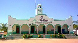
Architectural
San Roman Church, built during the colonial period (probably in the eighteenth century). The church of San Antonio de Padua, and the municipal building.
Archeological
Ek' Balam
References
Temozón Municipality Wikipedia(Text) CC BY-SA