
Founded 1555 Elevation of seat 1,720 m (5,640 ft) Elevation 1,720 m Local time Tuesday 2:17 PM | Municipal status 1835 Time zone CST (UTC-6) Population 30,336 (2005) | |
 | ||
Weather 27°C, Wind SW at 18 km/h, 25% Humidity | ||
Danza de caporales en temascaltepec de gonzalez
Temascaltepec (formally: Temascaltepec de González, for Plutarco González) is a city and seat of the municipality of Temascaltepec located in south of the State of Mexico in Mexico. It is 66 km (41 mi) southeast of Toluca and 140 km (87 mi), from Mexico City. Temascaltepec comes from the Náhuatl "temazcalli," which means "steam bath," and "tepetl," which means "hill." The Matlatzincas named the area "Cocalostoc," which means 'cave of crows'.
Contents
- Danza de caporales en temascaltepec de gonzalez
- Map of Temascaltepec de GonzC3A1lez State of Mexico Mexico
- The town
- Notable residents
- The municipality
- Natural features
- References
Map of Temascaltepec de Gonz%C3%A1lez, State of Mexico, Mexico
The town
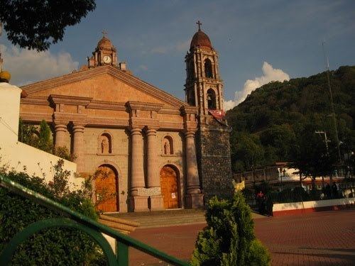
The first people known to live in Temascaltepec area were the prehispanic group Matlatzincas and probably founded the village were the modern town stands. During the Spanish conquest, it was delegated to Andrés de Tapia in 1556, with its first church built in 1559. The town grew after the discovery of silver deposits in 1545, and the area was a rich provider of minerals, including silver during the colonial era until after the Mexican War of Independence. In 1858, by decree of the state government, Temascaltepec was elevated to the category of town, and in 1861 was named Temascaltepec de González in honor of Plutarco González, a leader in the time of La Reforma. However, it is still known simply as Temascaltepec. The population of the town as of 2005 was 2,253.
Notable residents
The municipality
As municipal seat, the town of Temascaltepec has governing jurisdiction over the following communities: La Albarrada (San Francisco la Albarrada), San Sebastián Carboneras (Carboneras), Carnicería, El Cerro Pelón, Cieneguillas de González(Cieneguillas), Cieneguillas de Labra, La Comunidad, La Estancia de Tequesquipan, La Finca, La Guacamaya, Jesús del Monte, Labor las Cabras, Lampazos, Mesón Viejo, Milpas Viejas, Pedregales de Tequesquipan, El Peñón, Plan de Vigas, Potrero de San José (La Rinconada), Potrero de Tenayac, Real de Arriba, Rincón de Atarasquillo, Rincón de San Andrés, Rincón de Tequesquipan, El Salitre, San Andrés de los Gama, San Antonio Albarranes, San Francisco Oxtotilpan, San Lucas del Pulque, San Mateo Almomoloa, San Miguel Oxtotilpan, San Pedro Tenayac, Telpintla, San Martín Tequesquipan (Tequesquipan), Los Timbres, Las Trancas, El Tule, Manzana de Tequesquipan (Las Manzanas), San Juan, Hoyos de Vázquez, Cajones, La Cumbre, El Chilar del Ejido de las Trancas, Barrio la Magdalena (La Magdalena), Los Ocotes, Paredones, El Varal, Barrio de Cantarranas, Barrio la Cascada (Barrio del Varal), La Laguna, La Loba, Las Mesas de Real de Arriba, Pueblo Nuevo, Fraccionamiento Campestre Rancho Viejo, San José, El Salitre, Santanas, Ejido Real de Arriba, Manzana del Jabalí, Granjas de Cieneguillas, La Orejeta, Mina del Rincón, and Fraccionamiento Campestre.
Temascaltepec has 547.5 km2 of surface area. It borders the municipalities of Valle de Bravo, Amanalco de Becerra, TTejupilco, San Simón de Guerrero, Texcaltitlán, Zinacantepec, Coatepec Harinas, and Zacazonapan. Temascaltepec's population was 26,968 in 1990, but rose to 30,336 by 2005, according to INEGI.
Natural features
The Mountain of Temascaltepec is a prolongation of Nevado de Toluca and crosses the municipality. The most important elevations are the hills of Temeroso, Soledad, Fortin, Peñas del Diablo, Peñon, Tres Reyes and Juan Luis. The main rivers are three: Verde or De la Presa, Vado, and Temascaltepec, all with water flow year-round. In addition there are 41 freshwater springs. The municipality is warm and subtropical to the north and east and semi-arid to the south and west. Average temperatures vary between 18 to 22 °C (64 to 72 °F) and annual precipitation is from 800 to 1,600 mm (31 to 63 in).
The areas flora and fauna are varied. Plant life includes: ash trees (Fraxinus spp.), pine (Pinus spp.), oyamel (Abies religiosa), holm oak (Quercus ilex), cedar, sabino, guaje (Leucaena esculenta), tepegauje (Lysiloma acapulcense), madroño (Arbutus xalapensis), mahogany (Swietenia spp.), Jacaranda spp., capulín (Prunus salicifolia), guavas (Psidium spp.), such as arrayán (P. sartorianum), mangos (Mangifera spp.), copal (Copaifera spp.) and peanut (Arachis hypogaea).
Animal life includes cats deer, collared peccary (Pecari tajacu), squirrels, cuinique (Spermophilus spp.), long-tailed weasel (Mustela frenata), rabbits, hares, nine-banded armadillo, tejón (Nasua narica), tigrillo, bats, rats, pocket gophers, skunks, cacomiztle (Bassariscus astutus), gray fox (Urocyon cinereoargenteus), sparrowhawks (Accipiter spp.), eagles, vulture, common raven (Corvus corax), quebrantahueso (Caracara cheriway), owls, magpie-jays (Calocitta spp.), chachalaca, quail, huilota (Zenaida macroura), corn birds, turtledove, bobo, multo birds, chichicuilote (possibly Charadrius wilsonia), tortoises, cincuantes, scorpions, alicante, toads, lizards, frogs and axolotls (Ambystoma mexicanum).
The principal natural resource, aside from minerals, are the forests, being present on 68% of the territory. The rest is distributed for agricultural use, urban zones, breeding grounds, ways and water-bearing areas.