
 | ||
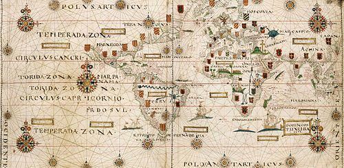
The Planisphere of Domingos Teixeira was made by this Portuguese cartographer shortly before becoming subject of Philip II of Spain, when this King inherited (and annexed after winning the war) the kingdom of Portugal in the Battle of Alcântara (1580).
Contents
It is made and painted by hand on a piece of parchment and conserved in the Bibliothèque nationale de France.
Datasheet
Description
It is one of the first full world maps showing the routes of spices islands, both the Portuguese of Vasco da Gama with their possessions, following the east route and the Spanish route towards the west, discovered by Ferdinand Magellan (shows the Terra Magellanica not yet circumnavigated by Diego Ramirez de Arellano that christened it Isla de Xativa.
You can see the scope of the Tordesillas Meridian, both on the side of America (Brazil) and at the opposite side of the world at the Philippines, that according to the treaty of Zaragoza should belong to Portugal, as they are in the "portuguese" hemisphere.