
Elevation 133 m Parent range Auckland volcanic field | Mountain range Auckland volcanic field | |
 | ||
Location Auckland, North Island, New Zealand Volcanic arc/belt Auckland volcanic field Address 113a Duke St, Mount Roskill, Auckland 1042, New Zealand Hours Open today · Open 24 hoursTuesdayOpen 24 hoursWednesdayOpen 24 hoursThursdayOpen 24 hoursFridayOpen 24 hoursSaturdayOpen 24 hoursSundayOpen 24 hoursMondayOpen 24 hoursSuggest an edit Similar Matukutururu, Maungarei, Maungawhau, Mount Richmond, Mount Hobson | ||
Te Tātua-a-Riukiuta (also known as Three Kings) is a volcano in Three Kings, New Zealand that erupted 28,500 years ago. The volcano had three prominent peaks and a number of smaller peaks until most of them were quarried away, leaving a sole remaining large peak.
Contents
Geology
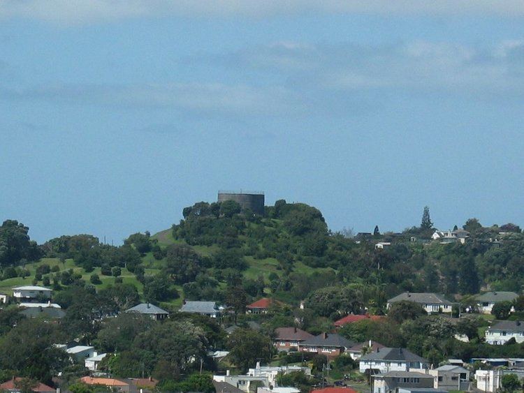
It was probably the most complex volcano in the Auckland volcanic field, consisting of five significant scoria cones and about a dozen smaller scoria mounds, sitting inside a large explosion crater. Along the edge of this crater to the south runs Mount Albert Road and to the north Landscape Road. The explosion crater, which was caused by the initial eruption, is the largest in Auckland, at 800 metres across and nearly 200 metres deep. The three largest scoria cones of the group were Big King at 133 m high, East King at 120 m high, and Highest King which was 135 m high.
Lava flows ran from here down a stream valley for three kilometres to Western Springs. These flows created lava tunnels which still exist under the ground surface. Thus rainwater falling on Te Tātua-a-Riukiuta and the surrounding area is channeled underground for miles until it emerges at Western Springs Lake. Most of these lava tunnels have collapsed but sections of them form caves and can be accessed from private properties in the area. It was formerly believed that the lava had travelled further and formed Meola Reef at Point Chevalier, but in 2008 it was discovered that the Meola Reef lava had come from the older Mount Saint John volcano.
The dating of the eruption to 28,500 years ago is one of the three most reliable eruption datings (as of 2011) for the more than 50 volcanoes in the Auckland volcanic field, the other two being Maungarei at 10,000 years ago, and Rangitoto Island, 500–1500 years ago. Charred twigs and wood were found in six boreholes drilled through Te Tātua-a-Riukiuta lava flows in 2006 and carbon dating of the organic material produced six very similar dates around 28,500 years.
History
An earlier name for the volcano was Te Tatua o Mataaho (the war belt of Mataaho), which referred to a deity living in the Maungawhau crater. It was later adapted to Te Tātua-a-Riukiuta, which referred to Riukiuta, a senior priest of the Tainui waka who brought together diverse genealogical lines of the local tribes. The name Three Kings derives from the biblical Magi, and was named by Captain William Hobson's surveyor Felton Mathew in 1841. Big King refers to the second-highest and only remaining peak.
Te Tātua-a-Riukiuta was the site of a pā, and Big King has retained Māori earthworks from that era such as kumara pits and terracing.
The area has been drastically quarried over the years for the red scoria it contains, and only one of the three large peaks (Big King) remains today, largely because of the water reservoir that was built on its summit at the beginning of the 20th century. The reservoir is below the hydraulic grade of the area and is hence maintained as an emergency supply reservoir only.
However, the large scoria deposits in the surrounding area are still being quarried. The groundwater level became a problem for the quarry in 1995, and Winstone Aggregates, the company operating the quarry, arranged with the Auckland City Council to supply the water to the region. However, as a result of local opposition to this arrangement, the water is instead discarded into the sea. The dewatering has led to concerns about subsidence of the ground.
In the 2014 Treaty of Waitangi settlement with the Tamaki Makaurau Collective of 13 Auckland iwi, the volcano was officially named Te Tātua-a-Riukiuta and ownership was vested to the collective. It is now co-governed by the collective and Auckland Council in common benefit of the iwi "and all other people of Auckland".