Neha Patil (Editor)

Taymyr River

Updated on
Edit
Like
Comment
Share on FacebookTweet on TwitterShare on LinkedInShare on Reddit
Native name
  
Таймыра

Country
  
Russia

River mouth
  
Kara Sea 0 m (0 ft)

Taymyr River

Main source
  
Confluence of two head rivers in the Byrranga Mountains. 150 m (490 ft)

Basin size
  
124,000 km (48,000 sq mi)

Length
  
840 km (520 mi) (total)

Discharge
  
Average rate: 1,220 m/s (43,000 cu ft/s)

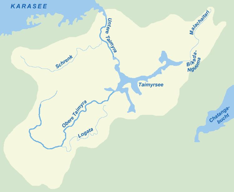
The Taymyr River (Russian: Таймыра, hence also known as Taimyra River) is a 840-mile (1,350 km) long river in Russia. It is located in the middle of the Taymyr Peninsula in the Krasnoyarsk Krai administrative region of the Russian Federation.

Contents

Map of r. Nizhnyaya Taymyra, Krasnoyarsk Krai, Russia

Course

  • The Upper Taymyr flows into Lake Taymyr from the west and is the largest river flowing into the lake basin. Its length is 567 km counting the 68 km stretch of the main one of its source rivers (Russian: Первая Голова Таймыры). Its main tributary is the Logata, coming from the right. The length of its course in the Taymyr Lake is 86 km.
  • The Lower Taymyr flows out of Lake Taymyr northwards across the Byrranga mountain region into the Taymyr Gulf. Its length is 187 km. The river's mouth forms an estuary where its waters join the Kara Sea. The Lower Taymyr River freezes up in late September or early October and stays under the ice until June on an average year. Its main tributary is the Shrenk, coming from the left.
  • References

    Taymyr River Wikipedia