
Country United States Elevation 591 ft (180 m) ZIP codes 48763-48764 Population 1,795 (2013) | County Iosco Time zone Eastern (EST) (UTC-5) Area code(s) 989 | |
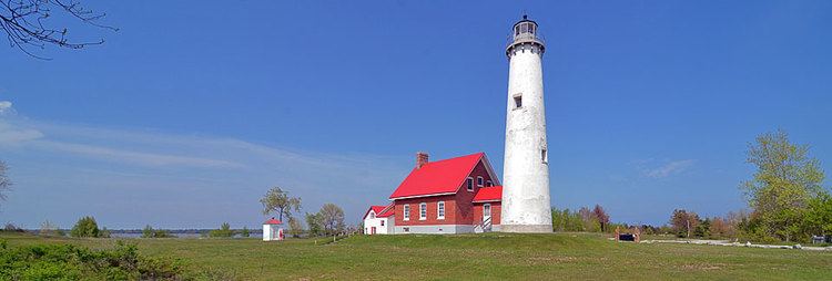 | ||
Weather 4°C, Wind W at 6 km/h, 100% Humidity Area 5.543 km² (4.455 km² Land / 109 ha Water) Points of interest Tawas Point State Park, Tawas Point Light, Tawas City Shoreline Park | ||
Tawas City is a city along Lake Huron in the Lower Peninsula of the U.S. state of Michigan. The population was 1,827 at the 2010 census. It is the county seat of Iosco County. The city is adjacent to Tawas Township but is administratively autonomous.
Contents
- Map of Tawas City MI 48763 USA
- History
- Geography
- 2010 census
- 2000 census
- Major highways
- Bus
- Local attractions
- Administration
- Education
- Area radio stations
- Television
- Newspapers
- References
Map of Tawas City, MI 48763, USA
History
Tawas City was founded in 1854 as the first city to be located on the shores of Saginaw Bay and Lake Huron north of Bay City. Tawas City was established as the county seat of Iosco County, and the first post office was established Jan. 6, 1856, with James O. Whittemore appointed postmaster.
Since Tawas City’s founding, the community’s economy has been a major factor influencing land use and development patterns in the city. The rich natural resource base of the area (forest lands, Lake Huron and wildlife) combined with the protection offered by Tawas Bay provided the basis for the original founding of the city and caused the lumber industry to flourish. Tawas Bay continues to serve as a harbor of refuge that large freighters use to escape the adverse effects of storms on Lake Huron. The shoreline, as the transition zone between land and water, became the focus of the community, with the city developing in a linear fashion along the bayshore.
Statements made that “Tawas” is derived from the word “Ottawas” and that the Ottawa Indians once inhabited this region are false. The Indians, who in early days camped along the shore of Tawas Bay and near the mouth of Tawas River, were a tribe from the Saginaw band of Chippewas. Their leader was Chief O-ta-was. What we know as Tawas Bay was in reality O-ta-was’ Bay, for on its shore the old chief had his camp. Early map makers dropped in an extra “t,” as can be easily verified; later map makers dropped off the “s,” for the name of the point of land that divided the bay from Lake Huron was known as Ottawa Point until comparatively recent spelling and pronunciation for the name of our earliest residents, have given us the name Tawas.
The Whittemores gave the name Tawas City to the town they founded in 1854. Eight years later, when the lumbering firm of Smith, Van Valkenburg and Company built a mill on the bay shore a mile or so east of the Whittemore mill and holding, and a community sprang up around this latter mill, the cluster of homes was, by common consent, named East Tawas. For many years, residents of both towns and the farming community surrounding them often referred to Tawas City as “old town” and to East Tawas as “east town.”
Geography
2010 census
As of the census of 2010, there were 1,827 people, 723 households, and 441 families residing in the city. The population density was 1,062.2 inhabitants per square mile (410.1/km2). There were 977 housing units at an average density of 568.0 per square mile (219.3/km2). The racial makeup of the city was 96.9% White, 0.7% African American, 0.2% Native American, 0.9% Asian, 0.4% from other races, and 0.8% from two or more races. Hispanic or Latino of any race were 1.4% of the population.
There were 723 households of which 23.8% had children under the age of 18 living with them, 45.1% were married couples living together, 11.9% had a female householder with no husband present, 4.0% had a male householder with no wife present, and 39.0% were non-families. 34.4% of all households were made up of individuals and 14.9% had someone living alone who was 65 years of age or older. The average household size was 2.22 and the average family size was 2.79.
The median age in the city was 47.4 years. 17.9% of residents were under the age of 18; 8.6% were between the ages of 18 and 24; 20.3% were from 25 to 44; 28.6% were from 45 to 64; and 24.6% were 65 years of age or older. The gender makeup of the city was 47.1% male and 52.9% female.
2000 census
As of the census of 2000, there were 2,005 people, 760 households, and 484 families residing in the city. The population density was 1,174.4 per square mile (452.7/km²). There were 969 housing units at an average density of 567.6 per square mile (218.8/km²). The racial makeup of the city was 97.31% White, 0.55% African American, 0.50% Native American, 0.65% Asian, 0.30% from other races, and 0.70% from two or more races. Hispanic or Latino of any race were 0.80% of the population.
There were 760 households out of which 26.6% had children under the age of 18 living with them, 49.2% were married couples living together, 10.7% had a female householder with no husband present, and 36.3% were non-families. 32.2% of all households were made up of individuals and 17.5% had someone living alone who was 65 years of age or older. The average household size was 2.29 and the average family size was 2.87.
In the city, the population was spread out with 21.5% under the age of 18, 5.7% from 18 to 24, 23.6% from 25 to 44, 21.0% from 45 to 64, and 28.1% who were 65 years of age or older. The median age was 44 years. For every 100 females there were 87.9 males. For every 100 females age 18 and over, there were 84.5 males.
The median income for a household in the city was $32,813, and the median income for a family was $37,235. Males had a median income of $28,789 versus $24,563 for females. The per capita income for the city was $16,061. About 8.8% of families and 9.6% of the population were below the poverty line, including 9.6% of those under age 18 and 11.0% of those age 65 or over.
Major highways
Bus
Local attractions
The City is on Tawas Bay, and Tawas Point State Park is located in nearby Baldwin Township. Both are considered to be an especially good locale for birding. and are listed as Important bird areas. It is said to be the most important "migrant trap" in the Saginaw Bay area. A fairly complete list of migratory birds that frequent the area is available. In more recent years Tawas Point has been a top kite-boarding destination.
Administration
Current as of April 2015
City Council
Education
Tawas Area Schools is a local public school district. The public schools consist of Clara Bolen Elementary, Tawas Middle School, Tawas Junior High, and Tawas High School. Emanuel Lutheran School is a private parochial elementary school in Tawas City, serving approximately 70 students in grades K-8. It is affiliated with the Wisconsin Evangelical Lutheran Synod.
Area radio stations
Television
Tawas City and Iosco County are part of the Flint-Saginaw-Bay City television market; Charter Communications, the cable system serving Iosco County, offers most major channels from that market, along with Alpena's CBS affiliate, WBKB-TV, as well as CBC Television programming from CBMT in Montreal.