I am a computer expert who loves a challenge. When I am not managing servers and fixing flaws, I write about it and other interesting things on various blogs.
Taupo Volcanic Zone
Updated on
Edit
Like
Comment
Share
Sign in
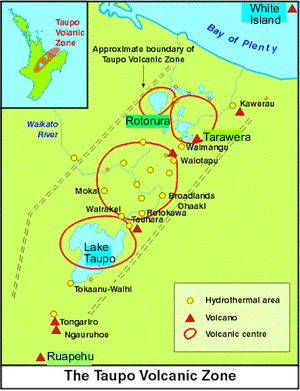
Geothermal features in the taupo volcanic zone
The Taupo Volcanic Zone is a highly active volcanic V-shaped area in the North Island of New Zealand that is spreading east–west at the rate of about 8 mm per year. It is named after Lake Taupo, the flooded caldera of the largest volcano in the zone.
There are numerous volcanic vents and geothermal fields in the zone, with Mount Ruapehu, Mount Ngauruhoe and White Island erupting most frequently. The zone's largest eruption since the arrival of Europeans was that of Mount Tarawera in 1886, which killed over 100 people. Early Maori would also have been affected by the much larger Kaharoa eruption from Tarawera around 1300 AD.
The last major eruption from Lake Taupo, the Hatepe eruption, occurred in 181 AD. It is believed to have first emptied the lake then followed that feat with a pyroclastic flow that covered about 20,000 square kilometres (7,722 sq mi) of land with volcanic ash. A total of 120 km3 (29 cu mi) of material is believed to have been ejected, and over 30 km3 (7.2 cu mi) of material is estimated to have been ejected in just a few minutes. The date of this activity is known since the ash expulsion was sufficiently large to turn the sky red over Rome and China (as documented in Hou Han Shu).
Taupo erupted an estimated 1,170 km3 (280 cu mi) of material in its Oruanui eruption 26,500 years ago. This was Earth's most recent eruption reaching VEI-8, the highest level on the Volcanic Explosivity Index.
The Rotorua caldera has been dormant longer, with its main eruption occurring about 240,000 years ago, although lava dome extrusion has occurred within the last 25,000 years.
Extent and geological context
The Taupo Volcanic Zone is approximately 350 kilometres (217 mi) long by 50 kilometres (31 mi) wide. Mount Ruapehu marks its southwestern end, while the submarine Whakatane volcano (85 kilometres (53 mi) beyond White Island) is considered its northeastern limit.
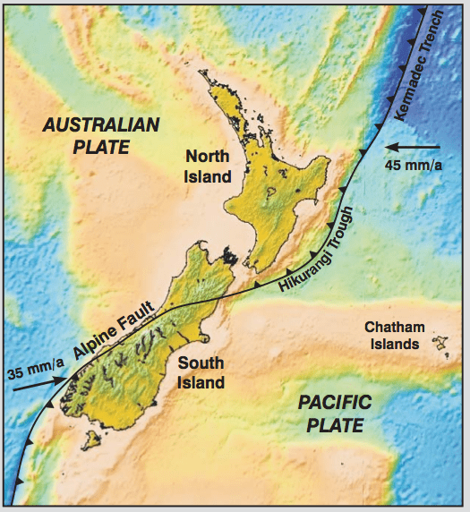
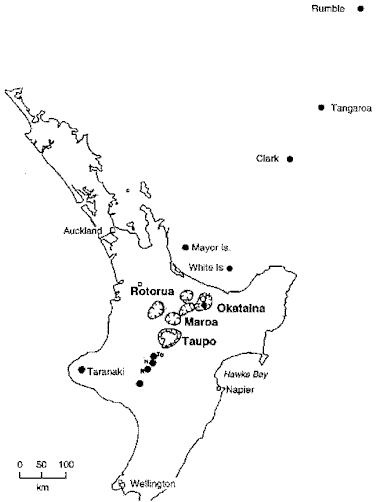
It forms a southern portion of the active Lau-Havre-Taupo back-arc basin, which lies behind the Kermadec-Tonga subduction zone. Volcanic activity continues to the north-northeast, along the line of the Taupo Volcanic Zone, through several undersea volcanoes (known as Clark, Tangaroa, the Silents and the Rumbles), then shifts eastward to the parallel volcanic arc of the Kermadec Islands and Tonga. Although the back-arc basin continues to propagate to the southwest, with the South Wanganui Basin forming an initial back-arc basin, volcanic activity has not yet begun in this region.
South of Kaikoura the plate boundary changes to a transform boundary with oblique continental collision uplifting the Southern Alps in the South Island. A subduction zone reappears southwest of Fiordland, at the southwestern corner of the South Island, although here the subduction is in the opposite direction. Solander Island is an extinct volcano associated with this subduction zone, and the only one that protudes above the sea.
Scientific study
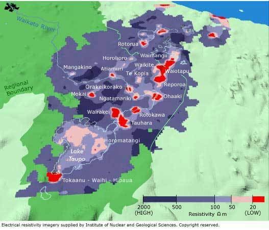
Recent scientific work indicates that the Earth's crust below the Taupo Volcanic Zone may be as little as 16 kilometres thick. A film of magma 50 kilometres (30 mi) wide and 160 kilometres (100 mi) long lies 10 kilometres under the surface. The geological record indicates that some of the volcanoes in the area erupt infrequently but have large, violent and destructive eruptions when they do. There is also some possible rifting in the Taupo Volcanic Zone.
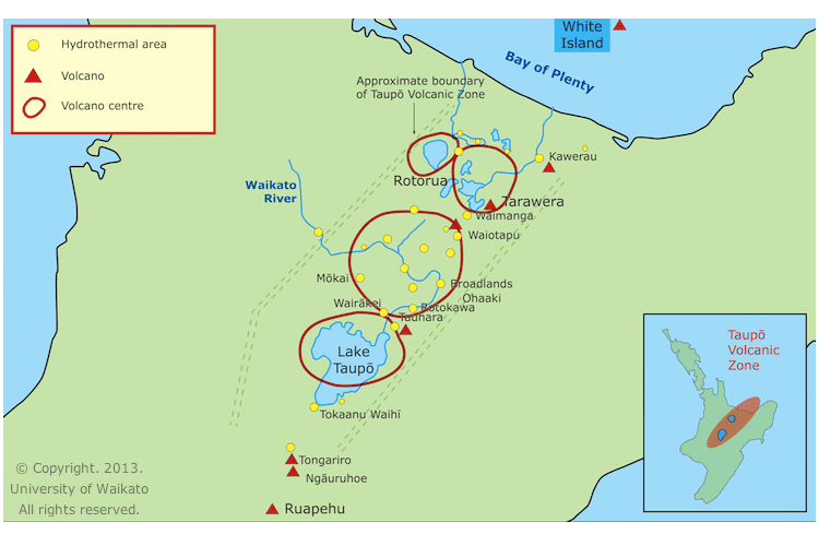
Volcanoes, lakes and geothermal fields
See also List of volcanoes in New Zealand#Taupo Volcanic Zone.
The following Volcanic Centers belong to the Taupo Volcanic Zone:
Rotorua, Okataina, Maroa, Taupo, Tongariro and Mangakino.
Lake Rotorua 38.08°S 176.27°E / -38.08; 176.27 (Lake Rotorua)
Mokoia Island 38°05′S176°18′E
Geothermal fields
Tikitere/Hell's Gate
Whakarewarewa 38°9′44″S176°15′23″E
Pohutu Geyser
Takeke
Okataina Volcanic Center: The Haroharo and Tarawera complexes impounded the lakes against the outer margins of the Okataina Caldera. The Okareka Embayment and the Tarawera Volcanic Complex are inside the Haroharo Caldera which in turn is inside the Okataina Ring Structure, from Newhall (1988), but newer maps show Okataina smaller.
Okataina Caldera, size: roughly 27 x 20 km 38.22°S 176.5°E / -38.22; 176.5 (Okataina Caldera)
Haroharo Caldera, size: 16 x 26 km
Haroharo volcanic complex, northern end of the Okataina Volcanic Center
Mount Tarawera and Tarawera volcanic complex 38.22°S 176.5°E / -38.22; 176.5 (Mount Tarawera)
Okareka vent
Okareka Embayment
Rotoma Caldera
Lakes
Lake Okataina 38°07′S176°25′E
Lake Tarawera 38°12′S176°27′E
Lake Rotokakahi (Green Lake) 38°13′S176°20′E
Lake Tikitapu (Blue Lake) 38°12′S176°20′E
Lake Okareka 38°10′S176°22′E
Lake Rotomahana 38°16′S176°27′E
Lake Rotoiti 38.0390°S 176.4277°E / -38.0390; 176.4277 (Lake Rotoiti)
Lake Rotoma 38.0476°S 176.5878°E / -38.0476; 176.5878 (Lake Rotoma)
Lake Rotoehu 38°1′S176°32′E
Geothermal fields
Waimangu Volcanic Rift Valley 38°16′57″S176°23′56″E
Frying Pan Lake
Rotoma
Maroa Volcanic Center: The Maroa Caldera formed in the Northeast corner of the Whakamaru Caldera, the Whakamaru Caldera partially overlaps with the Taupo Caldera on the South. The Waikato River course follows roughly the northern Maroa caldera rim on one side. The town of Whakamaru and the artificial Lake Whakamaru, on the Waikato River, have the same name too.
Maroa Caldera, size: 16 x 25 km 38.42°S 176.08°E / -38.42; 176.08 (Maroa Caldera)
Lake Rotoaira 39.0545°S 175.7143°E / -39.0545; 175.7143 (Lake Rotoaira)
Lake Rotopounamu 39.0267°S 175.7382°E / -39.0267; 175.7382 (Lake Rotopounamu)
Geothermal fields
Ketetahi Springs
Mangakino Volcanic Center: The Mangakino Volcanic Center is the westernmost and oldest rhyolitic caldera volcano in the Taupo Volcanic Zone. The course of the Waikato River crosses this area, between the artificial Lake Ohakuri (38.42273°S 176.125474°E / -38.42273; 176.125474 (Lake Ohakuri)), the town of Mangakino (38°23′S175°47′E) and Hamilton (37°47′S175°17′E).
Artificial Lake Maraetai
Other important features of the TVZ include the Whakatane, Ngakuru and Ruapehu grabens.
Note
There is nowadays a somewhat different classification:
North part: Whakatane Graben – Bay of Plenty
Central part:
West of the main fault zone:
Mangakino caldera complex; may be transitional between Coromandel Volcanic Zone (CVZ) and Taupo Volcanic Zone (TVZ) (1.62 – 0.91 mio. years old)
Kapenga caldera; lies between the Maroa caldera and the Rotorua caldera, it is completely buried under more recent tephra (circa 700,000 years old)
Okareka Embayment, lies inside the northern end of the Kapenga Caldera, between the Tarawera volcanic complex and the Lake Rotorua
Rotorua single event caldera; Mamaku Ignimbrite (circa 240,000 years old)
Main fault zone:
Okataina caldera complex
Haroharo caldera complex
Tarawera volcanic complex
Okareka Embayment
Whakamaru caldera complex
Maroa caldera
Ohakuri single event caldera; Ohakuri Ignimbrite; lies West of the Ohakuri Dam, the Waikato River course follows roughly the southern caldera rim on one side (circa 240,000 years old).
Taupo caldera complex
East of the main fault zone:
Reporoa single event caldera; Kaingaroa Ignimbrite (circa 240,000 years old)