
Country New Zealand Postcode(s) Map of postcodes Area 6,970 km² | Time zone NZST (UTC+12) Website taupodc.govt.nz Area code 07 | |
 | ||
Regions Waikato (majority)
Bay of Plenty (part)
Hawke's Bay (part)
Manawatu-Wanganui (part) Main towns and settlements Taupo, Kinloch, Turangi, Mangakino | ||
Taupo district council live stream
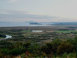
The Taupo District is a district in New Zealand. It covers 6,350 km² of land, as well as a further 610 km² of lake area, both in Lake Taupo, New Zealand's largest lake, and also in the smaller Lake Rotoaira. The district stretches from the small town of Mangakino in the northwest to the Tongariro National Park in the south, and east into the Kaingaroa Forest. The district's population is largely located in the two main centres, Taupo and Turangi.
Contents
Taupo district council live stream
Local government
The district is governed by the Taupo District Council, with the vast majority of the district falling within the jurisdiction of Environment Waikato regional council.
History
Little is known about early Māori settlement near Taupo, although Ngati Tuwharetoa have been the main iwi of the area for several hundred years. Major pa were situated at the southern end of the lake to the west of the modern town of Turangi.
Taupo town was founded in 1869 as a garrison town during the New Zealand Wars, but remained small due to the poor volcanic soils of the region. It was not until the 1950s that the region started to develop, with forestry and the construction of the Wairakei geothermal power station.
Population
The town of Taupo is situated on the north-eastern shore of the lake, and Turangi is at the lake's southern extremity.
State Highway 1 winds along the eastern shore of Lake Taupo, and several small townships are located along it. Fewer people live on the northern or western shores, although there are several small settlements close to Taupo, and to the west of Turangi (notably at Tokaanu)
In the 2006 census the resident population was: