
Country New Zealand Region Waikato Mayor David Trewavas | Area 132.57 km2 Founded 1869 | |
 | ||
Points of interest Lake Taupo, Huka Falls, Huka Prawn Park, Aratiatia Power Station, Mount Tauhara | ||
Map of Taupo
Taupō (; [ˈtoʊpɔː])) is a town on the shore of Lake Taupō in the centre of the North Island of New Zealand. It is the seat of the Taupō District Council and lies in the southern Waikato Region.
Contents
- Map of Taupo
- Adventure activities in lake taupo
- Replete food co taupo ezypeezy coupons
- Geography
- Neighbourhoods
- Climate
- Economy
- Education
- Sporting events
- Annual events
- Past events
- Transport
- Twin cities
- References
Taupō has a population of 24,100 (June 2016). In 1953, Taupō was officially constituted as a borough, but from 1989 it has been administered by the Taupo District Council, the district including both Taupō itself and the surrounding hinterland. Despite this, it is occasionally referred to as a city. It is the 20th largest urban area in New Zealand, and the second-largest in the Waikato Region (behind Hamilton).
The name Taupō, by which the town is commonly known, is the shortened version of its full name, Taupō-nui-a-Tia. Literally translated from Māori language, Taupō-nui-a-Tia means "The great cloak of Tia", where Tia is the name of the discoverer of the lake.
In 2009 a team of Taupō citizens won the TV2 programme Top Town.
Adventure activities in lake taupo
Replete food co taupo ezypeezy coupons
Geography
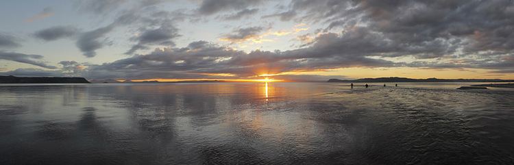
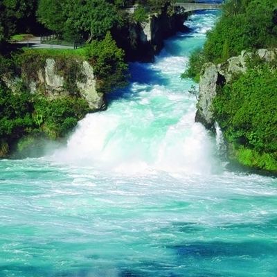
Taupō is located at the outlet of Lake Taupō, New Zealand's largest lake, in the northeast part of the lake where it discharges to the Waikato River. The river flows over the spectacular Huka Falls, a short distance north of the town. Taupō is a centre of volcanic and geothermal activity and hot springs suitable for bathing are located at several places in the vicinity. The volcanic Mount Tauhara lies six kilometres (4 mi) to the east.
Somewhat to the northeast are significant hot springs. These springs contain extremophile micro-organisms that live in extremely hot environments.
Taupō is situated on a stretch of State Highway 1, running concurrently with State Highway 5. It is situated 53 km north of Turangi. It is one of the few centres in New Zealand that were never linked to the rail network.
The small but growing satellite town of Kinloch, where there is a golf course designed by Jack Nicklaus, is 20 kilometres west along the lake.
Neighbourhoods
Taupō neighbourhoods include:
Climate
The climate of Taupō is cold and windy when compared to other parts of the North Island. This is due to the town being located inland, which results in the accumulation of dry air causing severe frost during winter. However snowfall in Taupō is rare. The summer climate in Taupō is mild with maximum average temperature reaching 23 degrees and a minimum average temperature of 10 degrees.
Economy
Taupō is a tourist centre, particularly in the summer, as it offers panoramic views over the lake and to the volcanic mountains of Tongariro National Park to the south. It offers a number of tourist activities including sky diving, jet boating and paragliding.
Taupō services a number of surrounding plantation pine forests including Kaingaroa Forest, the largest manmade forest in the world, and related industry. A large sawmill is sited approximated 3 km to the north east of the town on Centennial Drive.
The Wairakei geothermal power station is a few kilometres north of the town.
Education
Taupō has three high schools: Tauhara College, Taupo Nui-a-Tia College and state integrated Lake Taupo Christian School. It also has Wairakei, St Patrick's, Waipahihi, Hilltop, Mount View, Taupō and Tauhara primary schools, and Taupō Intermediate School.
Sporting events
Since the mid-1990s Taupō has become increasingly popular as a venue for major sporting events, increasingly of an international nature. The town's compact size, clean environment, central location and supportive council and community have been cited as the reasons for this. Major events in Taupō include:
Annual events
Past events
The International Mountain Bicycling Association has designated the mountain biking trails at Bike Taupō as a silver-level IMBA Ride Center. Ride Centers are the IMBA's strongest endorsement of a trail experience.
Transport
Taupō is served by State Highway 1 and State Highway 5, and the Thermal Explorer Highway touring route. All three highways run concurrently along the Eastern Taupō Arterial, which was built in 2010. SH 5 diverts east on the Napier-Taupō Road. Before this SH 1 and SH 5 began concurrently from Wairakei in the north, along Tongariro Street and Lake Terrace.
Taupo is one of the few large towns in New Zealand that have never had a link to the national rail network (the others being Queenstown and Nelson), although there have been proposals in the past.
Taupō Airport is located south of the township. The airport is served by Air New Zealand subsidiary Air Nelson, with direct flights using Bombardier Q300 aircraft to Auckland. Flights to and from Wellington are served by Sounds Air using nine-seater Pilatus PC12 – a single-engine, turboprop aircraft.