Rahul Sharma (Editor)

Tatti, Massa Marittima

Updated on
Edit
Like
Comment
Share on FacebookTweet on TwitterShare on LinkedInShare on Reddit
Country
  
Comune
  
Demonym(s)
  
Tatterini

Province
  
Region
  
Elevation
  
412 m (1,352 ft)

Time zone
  
CET (UTC+1)

Tatti, Massa Marittima wwwtattiitimgareajpg

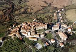
Tatti is a village in Tuscany, central Italy, administratively a frazione of the comune of Massa Marittima, province of Grosseto, in the area of the Colline Metallifere. At the time of the 2001 census its population amounted to 231.

Contents

Map of Tatti, Province of Grosseto, Italy

Tatti is about 37 km from Grosseto and 20 km from Massa Marittima, and it is a small medieval village (11th century) situated on a hill of Colline Metallifere.

Main sights

  • Santa Maria Assunta, main parish church of the village, it was built in the 12th century and rebuilt in the 19th century in a Neoclassical style.
  • San Sebastiano, an ancient little church restructured in the 18th century.
  • Santissima Annunziata, a church of medieval origins, it is situated outside the centre of the village.
  • Rocca Aldobrandesca, a 13th-century fortress built by the Aldobrandeschi.
  • Walls of Tatti, old fortifications which surround the village since the 9th century (rebuilt in the 13th century).
  • References

    Tatti, Massa Marittima Wikipedia