
Type Mountain glacier Length 23.5 km (14.6 mi) Terminus Lake Tasman Area 101 km² | Thickness 600 m (2,000 ft) Status Retreating | |
 | ||
Similar Aoraki/Mount Cook National, Aoraki / Mount Cook, Hooker Valley Track, Southern Alps, Franz Josef Glacier | ||
The Tasman Glacier is the largest of several glaciers which flow south and east towards the Mackenzie Basin from the Southern Alps in New Zealand's South Island. It is New Zealand's longest glacier.
Contents
- Map of Tasman Glacier Canterbury 7999 New Zealand
- Geography
- Recent retreat
- Access and tourism
- References
Map of Tasman Glacier, Canterbury 7999, New Zealand
Geography
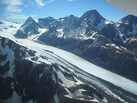
At 23.5 kilometres (14.6 mi) in length, Tasman Glacier is still New Zealand's longest glacier, although it has shrunk considerably from the 1990s onwards. It is as much as 4 kilometres (2.5 mi) wide and 600 metres (2,000 ft) thick, and lies entirely within the borders of Aoraki/Mount Cook National Park. The glacier covers an area of 101 square kilometres (39 sq mi) and starts at a height of 3,000 metres (9,800 ft) above sea level. Snowfall during the winter and spring seasons accumulates to 50 metres (160 ft). After the summer melt, 7 metres (23 ft) remains.
The Tasman flows south from the southern slopes of the Minarets peak, along the eastern flank of New Zealand's two highest mountains, Mount Tasman and its higher southern neighbour Aoraki / Mount Cook.
Although its upper reaches are snow-covered, rocks carried by the glacier are exposed by ablation along its course, and the lower glacier is entirely rock-covered. The rock cover helps insulate the ice from the sunlight and slows down the melting process. Tributaries in the lower parts are the Rudolf Glacier, Forrest Ross Glacier, Kaufmann Glacier, Haast Glacier, Hochstetter Glacier, and Ball Glacier.
The glacier is almost met near its end by the meltwater of the Murchison Glacier, which approaches from the northeast before turning to flow beside the Tasman Glacier outside the moraine wall. The waters from both these glaciers pool at the end of the glacier in Lake Tasman, before flowing south to join the outflow from the nearby Hooker and Mueller Glaciers in the wide valley of the Tasman River, whose braided streams flow south into Lake Pukaki. They eventually flow into the Waitaki River and to the Pacific Ocean north of Oamaru.
Recent retreat
The glacier remained at a constant 28 km (17 mi) in length for all of its recorded history in the 20th century before starting its current period of rapid melting in the 1990s. Between 2000 and 2008 alone, the glacier terminus receded 3.7 km. Since the 1990s the terminus has retreated about 180 metres (590 ft) a year on average. The glacier is now in a period of faster retreat where the rate of retreat is calculated to be between 477 to 822 metres (1,565 to 2,697 ft) each year. It is estimated that the Tasman Glacier will eventually disappear and the terminal Tasman Lake will reach a maximum size in 10 to 19 years time. In 1973 Tasman Glacier had no terminal lake and by 2008 Tasman Lake was 7 kilometres (4.3 mi) long, 2 kilometres (1.2 mi) wide, and 245 metres (804 ft) deep.
A large calving event was possibly triggered, or at least contributed to, by the 2011 Canterbury earthquake on 22 February 2011. On this day 30,000,000 metric tons (33,000,000 short tons) to 40,000,000 metric tons (44,000,000 short tons) of ice dropped from the terminal face of the Tasman Glacier and fell into the Tasman Lake. Boats were hit with tsunami waves of up to 3.5 metres (11 ft) as the ice fell into the Tasman Lake under the glacier. Similar events in the past have been attributed to buoyancy effects, a result of high basal water pressures and increased lake level following heavy rainfall events.
Access and tourism
Tasman Glacier has a long history of tourism, with heli skiing tours offered on the upper glacier since the early 1970s. The tributary Ball Glacier was also popular for skiing, with national championships being held there in the 1930s. It has since diminished too far to be safely accessed. Similarly, Tasman Glacier's significant ice loss over the past decades has impacted tourism, with an increasing number of crevasses being exposed and not filled in by snow anymore, requiring guided tours to avoid these areas, and restricting the heli skiing season to July, August and September.
The proglacial Tasman Lake is a popular destination for boat tours among the icebergs often floating in the lake. Boats are not allowed closer than 1.5 km (0.9 mi) to the 50 m (160 ft) tall terminal face of Tasman Glacier for safety reasons.
The Ball Shelter Track, part of the Ball Hut Route, leads along the western side of the glacier, separated from Tasman Lake by a tall moraine wall until about 6 kilometres in, where it climbs high enough for the view to open up. At that point, the rock-covered lower Tasman Glacier in the valley between the moraine walls is 2.5 km (1.6 mi) wide.