
River mouth Bay of Plenty Mouth Bay of Plenty | Length 65 km | |
 | ||
Basin size 906 km (350 sq mi) (measured up to Awakaponga) Discharge Average rate:26 m/s (920 cu ft/s) | ||
Tarawera river kawerau action 3
The Tarawera River is in the Bay of Plenty Region in the North Island of New Zealand.
Contents
- Tarawera river kawerau action 3
- Map of Tarawera River Bay Of Plenty New Zealand
- Rafting on the tarawera river kawerau new zealand
- Environmental issuesEdit
- References
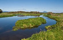
Map of Tarawera River, Bay Of Plenty, New Zealand
It flows from Lake Tarawera, northeastwards across the northern flanks of the active volcano Mount Tarawera, and past the town of Kawerau before turning north, reaching the Bay of Plenty 6 kilometres (4 mi) west of Edgecumbe.
The Tarawera Falls on the river are considered to be quite spectacular.
Rafting on the tarawera river kawerau new zealand
Environmental issuesEdit
The Tasman Pulp and Paper Mill, now owned by Norske Skog, has been discharging waste into the river since 1955. Local residents have erected signposts labelling the river as the "Black Drain" since the 1990s.
The dark colour is due to the presence of pollution from farms, sewage and stormwater but it is predominantly from pulp and paper mill effluent. As of 1997, pulp and paper mills were discharging over 160 million litres of industrial waste into the river per day. By 2006, the oxygen levels in the river had reached a level where fish could survive, however the water colour was still dark. Since 1998 the colour and light penetration (euphotic depth) have improved in the lower section of the river due to less pollution from the Tasman Mill.
In 2009, the mill gained permission to continue polluting the river for the next 25 years. In 2010, local iwi took a case to the High Court to shorten the 25 year water discharge permits issued under the Resource Management Act but the appeal was rejected.