
 | ||
Taprobana (Ancient Greek: Ταπροβανᾶ) or Taprobane (Ταπροβανῆ) was the historical name for present Sri Lankan island in the Indian Ocean.
Contents
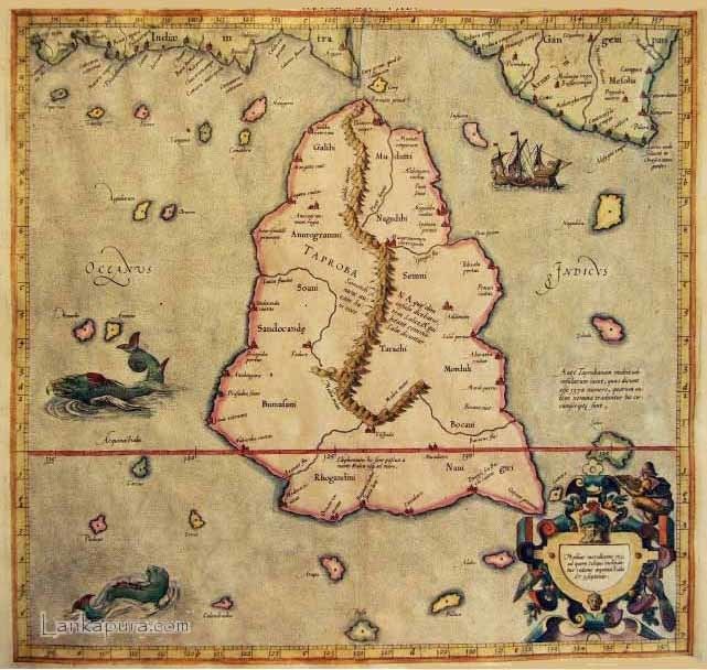
Map of Sri Lanka
History
Reports of the island's existence were known before the time of Alexander the Great as inferred from Pliny. The treatise De Mundo (supposedly by Aristotle (died 322 BC) but according to others by Chrysippus the Stoic (280 to 208 BC)) states that the island is as large as Great Britain. The name was first reported to Europeans by the Greek geographer Megasthenes around 290 BC. Herodotus (444 BC) does not mention the island. The first Geography in which it appears is that of Eratosthenes (276 to 196 BC) and was later adopted by Ptolemy (139 AD) in his geographical treatise to identify a relatively large island south of continental Asia.
Taprobana may be the Greek rendition of Tamraparni or Tambapanni, meaning "copper-colored," the descriptive name of one of the rivers of the Indian state of Tamil Nadu. According to Western legend, the inhabitants had a single giant foot that they used to protect themselves from the sun.
For some time the exact place to which the name referred remained uncertain. The likely possibilities included:
The identity of Ptolemy's Taprobane has been a source of confusion, but it appeared to be the present day Sri Lanka in the medieval maps of Abu-Rehan (1030) and Edrisi (1154) and in the writing of Marco Polo (1292). However, in the maps of the Middle Ages, the fashion of using Latinised names and delineating places with fanciful figures contributed to absurd designs and confusion regarding the island and Sumatra. In the fifteenth century, Niccolò de' Conti mistakenly identified Taprobana with a much smaller island. Taprobana/Ceylon/Sri Lanka is marked in the 1507 Martin Waldseemuller map.
The question of whether the Taprobana shown in Ptolemy's map was Sri Lanka or Sumatra—resurfaced with the display of Sebastian Munster’s 1580 map of Taprobana, carrying the German title, Sumatra Ein Grosser Insel, meaning, "Sumatra, a large island". The map was displayed at the Australian National Library Map Gallery from January to March 2008. The original debate had been settled earlier in favor of Sri Lanka, but Munster’s map reopened it. Ptolemy's map had been lost at the time of its production around the 2nd century AD. However, copies were rediscovered in the Middle East around 1400 AD. By that time the Portuguese had had made their way into Asia. They had knowledge of both Sri Lanka (then Ceylan) and Sumatra beginning at least 80 years before. Munster’s map was based on Ptolemy’s map, so Munster apparently based his identification of Taprobane with Sumatra on 16th century knowledge.
Taprobana is mentioned in the first strophe of the Portuguese epic poem Os Lusíadas by Luís de Camões (c. 1524 – 10 June 1580).
As armas e os barões assinalados,
Que da ocidental praia Lusitana,
Por mares nunca de antes navegados,
Passaram ainda além da Taprobana,
Em perigos e guerras esforçados,
Mais do que prometia a força humana,
E entre gente remota edificaram
Novo Reino, que tanto sublimaram
In literary works, Taprobana was mentioned in Tommaso Campanella's The City of the Sun, written in 1602. Jorge Luis Borges mentions the island in the story "The Lottery in Babylon" in the collection The Garden of Forking Paths (1941) of his book Fictions (1944). Toprobana is the fictional location of the sky elevator in Arthur C. Clarke's science fiction novel The Fountains of Paradise" (1979). British rock band My Vitriol's 2001 debut album Finelines features a track called Taprobane, courtesy of the bands lead singer Som Wardner who is of Sri Lankan origin.