
Municipality Tamazula Postalcode 34580 Population 2,337 (2010) | Time zone CST (UTC-6) Elevation 245 m Local time Saturday 10:46 PM | |
 | ||
Weather 21°C, Wind N at 0 km/h, 55% Humidity | ||
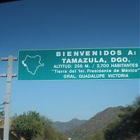
Tamazula de Victoria is a small town and seat of the municipality of Tamazula in the Mexican state of Durango, near the Sierra Madre Occidental mountains. The town is located about 1.5 hours east of Culiacán, Sinaloa. General Guadalupe Victoria, the first president of Mexico, was born there, hence the name. Its official name is Tamazula de Victoria. As of 2010, the town had a population of 2,337
Map of Tamazula de Victoria, Durango, Mexico
The municipal subdidisions of Tamazula are:
Amaculi, Los Remedios, El Chicural, El Cocoyole, Chacala, El Llano, El Comedero, Las Juntas, Las Quebradas, El Río, Pueblo Viejo, El Carrizo, Otatitlán, Las Coloradas, La Nonte, El Cajón, La Mesa del Rodeo, El Durazno, la Alameda, Santa Gertrudis, and El Tecuán.
References
Tamazula de Victoria Wikipedia(Text) CC BY-SA