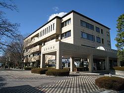
Country Japan District Sawa - Flower Rose Population 36,952 (Feb 2015) Prefecture Gunma Prefecture | Region Kantō - Tree Osmanthus Area 25.78 km² Local time Sunday 12:21 PM | |
 | ||
Time zone Japan Standard Time (UTC+9) Weather 5°C, Wind E at 11 km/h, 86% Humidity University Gunma Prefectural Women's University Points of interest Tamamuracho Hokubu Park, Tamamuramachi Historical Museum, Tamamuracho Tobu Sports Hiroba Park | ||
Tamamura (玉村町, Tamamura-machi) is a town located in Sawa District, Gunma Prefecture, in the northern Kantō region of Japan. As of February 2015, the town had an estimated population of 36,952 and a population density of 1430 persons per km². Its total area was 25.78 km².
Contents
- Map of Tamamura Sawa District Gunma Prefecture Japan
- Geography
- Surrounding municipalities
- History
- Economy
- Education
- Transportation
- Highway
- References
Map of Tamamura, Sawa District, Gunma Prefecture, Japan
Geography
Tamamura is located in southern Gunma prefecture in the northern extremity of the Kantō plains, bordering Saitama Prefecture to the south. The Tama River flows through the town.
Surrounding municipalities
History
Tamamura developed during the Edo period as a post town on the Nikkō Reiheishi Kaidō, a subroute to Nikkō Kaidō which connects the Nakasendō with Nikkō, bypassing Edo.
Modern Tamamura town was created within Nawa District, Gunma Prefecture on April 1, 1889 with the creation of the municipalities system after the Meiji Restoration. Nawa District and Sai District merged to form Sawa District in 1896. On April 10, 1955 Tamamura annexed the neighboring village of Shibane, followed by Jōyō on August 1, 1957
Economy
Many people were employed in sericulture in the past.
Education
Transportation
Tamamura is not served by any railway lines. The nearest station is Shinmachi Station in the neighboring city of Takasaki.
