
Elevation 33 m Local time Saturday 8:19 PM | Time zone PST (UTC-8) Area 206 ha Population 7,000 (2009) | |
 | ||
Weather 12°C, Wind W at 14 km/h, 80% Humidity | ||
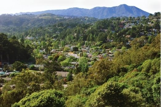
Tamalpais Valley (also known as "Tam Valley", and formerly called "Big Coyote", "Coyote Valley" or "Coyote Hollow" until 1908) is an unincorporated community in Marin County, California.
Contents
- Map of Tamalpais Valley Tamalpais Homestead Valley CA 94941 USA
- Land
- People
- Government
- History
- Recreation
- Points of interest
- References
Map of Tamalpais Valley, Tamalpais-Homestead Valley, CA 94941, USA
Land
Tamalpais Valley is located at 37°53′19″N 122°32′23″W. and is about 509 acres in size, with an elevation of 108 feet (33 m). The nearest cities are Mill Valley to the north and Sausalito to the south. Traveling by car, Tamalpais Valley is located about 10 minutes from the Golden Gate Bridge and fifteen minutes from San Francisco. California State Route 1 (also known as Shoreline Highway and the Pacific Coast Highway) runs through the Valley and is the road most often used to access western Marin County.
Nearby landmarks include the Golden Gate National Recreation Area (GGNRA), Mount Tamalpais State Park, Muir Woods National Monument, Tennessee Valley and Muir Beach.
A large portion of Tamalpais Valley is federal parkland - the Golden Gate National Recreation Area. The area's wooded canyons host a diverse wildlife that includes deer, racoons, squirrels, skunks, coyotes, foxes, chipmunks, bobcats and mountain lions - as well as a wide variety of birds, including humming birds, sparrows, robins, blue jays, hawks and buzzards.
People
In 2009, Tamalpais Valley's population was estimated at about 7,000 (nearly the same size as Sausalito). For census purposes, Tamalpais Valley is aggregated with Homestead Valley into the census-designated place Tamalpais-Homestead Valley.
Government
Tamalpais Valley is an unincorporated community of approximately 2,800 households, plus a few small businesses. Its local governmental agency is the Tamalpais Community Services District (TCSD), whose board of directors is elected by residents.
History
Tamalpais Valley was first inhabited by Native Americans tribes such as the Tamal and Miwok Indians, who left the area with the establishment of the Spanish mission and Presidio in San Francisco. Called Coyote Hollow on 19th century maps, it was granted as part of Rancho Saucelito to William Richardson in 1838. The land was acquired by attorney Samuel Reading Throckmorton, then title passed to the San Francisco Savings Union. Eventually dairymen of Portuguese Azorean birth purchased the area, among them the Dias and Pimentel/Silva families. For approximately 60 years these families operated a dairy ranch on the property, where family members still reside. Finally S.A. Moss purchased most of the property, and developers Cranston, Belvel & Dwyer renamed it Tamalpais Valley; 125 lots were put up for sale to private purchasers in 1908.
Tamalpais Valley's working class and rural community grew at a fast pace during the 1920s as more families settled in the area. Small businesses, such as the Tamalpais Service Station, were opened along Shoreline Highway. By the 1950s, it had become a suburban settlement with its own primary school, sewer system and local government.
Recreation
The area offers a wide range of hiking and biking trails, featuring scenic views of Mount Tamalpais and the Marin Headlands, as well as the Pacific Ocean and San Francisco Bay. Some of the most popular nearby trails include Tennessee Valley, Miwok trail, Dias trail and Mountain Home trail, to name only a few.