
Country Honduras Area 82 km² | Department Lempira Population 10,744 (2015) | |
 | ||
Talgua ([ˈtalɣwa]) is a municipality in the Honduran department of Lempira.
Contents
Map of Talgua, Honduras
History
Talgua was founded in the colonial period in the place called "Las Mercedes" village. Also it was known as a village where Lenca Indians dwelled, by Pedro de Alvarado and his troops. In the administration of president Ramon Villeda Morales, on January 2, 1963, the capital was moved from Talagua to San Antonio de Pedernales. The old church is preserved as a relic.
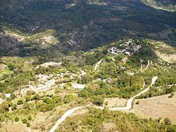
Geography
It is located right on top a small hill on the side of a river. But there are high mountains around its capital and some of these belong to Copán department. The weather is hot because of the elevation from sea level and the vegetation, which consists of dry sub tropical forest. Some pine trees are seen on the highest hills.
Boundaries
Its boundaries are:
Population
Mestizos are up to 80% of the population, the remaining percent consists of indigenous Lenca communities.