
Width 7 km (4.3 mi) Area 26 km² | Length 24.7 km (15.35 mi) Commune Takaroa Archipelago Tuamotus | |
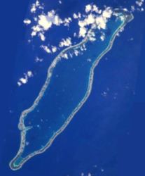 | ||
Takaroa, Taka-roa or Takapua, is an atoll in the Tuamotu group in French Polynesia. It has a length of 27.4 kilometres (17.0 miles) and a width of 7 km (4 mi); its land area is 20 square kilometres (8 square miles).
Contents
Map of Takaroa, French Polynesia
The nearest land is Takapoto Atoll, located 10 kilometres (6 miles) to the southwest.
Fine pearls, including black pearls, were obtained in the lagoon of Takaroa.
Geographically Takaroa is part of the King George Islands (Iles du Roi Georges) subgroup, which includes Ahe, Manihi, Takapoto, Takaroa and Tikei.
Takaroa Atoll has 882 inhabitants. The main village is Teavaroa.
History
The first recorded Europeans to arrive to Takaroa were Dutch explorers Jacob le Maire and Willem Schouten on 14 April 1616 during their Pacific journey. They called this atoll "Sondergrond Island".
Takaroa territorial airport was inaugurated in 1986.
Administration
The commune of Takaroa consists of the atolls of Takaroa and Takapoto, as well as Tikei Island.