
Basin size 820 sq mi (2,100 km) Basin area 2,124 km² | Length 143 km Country United States of America | |
 | ||
Bridges M-28-Tahquamenon River Bridge | ||
Lower tahquamenon river michigan
The Tahquamenon River is an 89.1-mile-long (143.4 km) blackwater river in the U.S. state of Michigan that flows in a generally eastward direction through the eastern end of the Upper Peninsula. It drains approximately 820 square miles (2,120 km2) of the Upper Peninsula, including large sections of Luce County and Chippewa County. It begins in the Tahquamenon Lakes in northeast Columbus Township of Luce County and empties into Lake Superior near the village of Paradise. M-123 runs alongside a portion of the river.
Contents
- Lower tahquamenon river michigan
- Map of Tahquamenon River Michigan USA
- NameEdit
- Tahquamenon FallsEdit
- RecreationEdit
- Tour boatEdit
- References
Map of Tahquamenon River, Michigan, USA
NameEdit
The meaning of "Tahquamenon" is not known. Some called it the "River of the Head Winds" because they bucked the wind on the lower river no matter what direction they were paddling. Others called it the "River of a Hundred Bends". Twentieth century descendants of local Chippewa translated the name to mean "river up against a hill" or "lost river island" or "river with an island part way". In 1930 Jesuit scholar, Father William Gagnieut, concluded that the meaning of the name had been lost.
Recorded variously as 'Otikwaminang,' 'Outakwamenon,' 'Tequamenen', 'Tanguamanon,' 'Tanquamanon,' 'Toumequellen' and 'Tahquamenaw', several suggestions on the meaning of its name have been made over the years:
The current name for the Tahquamenon River in the Ojibwa language is Adikamegong-ziibi "River where the Whitefish are found." This name is also the naming basis for the Whitefish Point and Whitefish Bay, both known earlier as "Tahquamenaw".
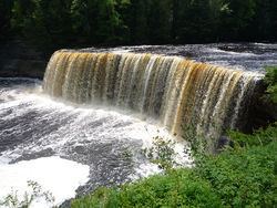
Tahquamenon FallsEdit
The river is best known for the Tahquamenon Falls, a succession of two waterfalls in Tahquamenon Falls State Park totalling approximately 73 feet (22 m) in height. Because the headwaters of the river are located in a boreal wetland that is rich in cedar, spruce and hemlock trees, the river's waters carry a significant amount of tannin in solution (i.e., it is a blackwater river), and are often brown or golden-brown in color. The Tahquamenon Falls are thus acclaimed as being the largest naturally dyed or colored waterfall in the United States. The state park preserves the falls area and some 24 miles (39 km) of the river.
RecreationEdit
In Henry Wadsworth Longfellow's once-famous poem, The Song of Hiawatha (1855), the hero learned how to paddle a birchbark canoe in the Tahquamenon. The river is often used for canoeing to this day. The river's watershed and state park are also extensively used for fishing and hiking. In winter, the watershed welcomes snowmobilers.
Tour boatEdit
The Toonerville Trolley Train and Riverboat Tour, a private firm, offers 21-mile (34 km) boat tours of the upper Tahquamenon as part of an overall family experience that includes a narrow-gauge rail ride and visit to the Upper Tahquamenon Falls. The tour is based in Soo Junction, between Newberry and Hulbert.