
Easiest route Hike | Elevation 1,748 m | |
 | ||
Similar Pushpagiri, Brahmagiri (hill) - Kar, Kodachadri, Mullayanagiri, Kote Betta | ||
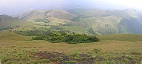
Tadiandamol (Kannada: ತಡಿಯಂಡಮೋಳು, Tadiyandamolu, Kodava : ತಡಿಯಂಡಮೋಳ, Tadiyandamol, ) is the highest mountain of Kodagu district, Karnataka, India. It is the fourth highest peak in Karnataka. It is located Western Ghats range, and reaches an elevation of 1,748 m. The mountain has patches of shola forests in the valleys.
Contents
Map of Tadiandamol, Yevakapadi, Karnataka 571212
The Nalaknad (also known as Nalnad - meaning 4 villages) palace at the foothills is an important historical landmark. This was one of the landmarks mapped during the Great Trigonometric Survey.
It is a place of interest for trekkers and naturalists. The climb to the top and back can be completed as a day hike; camping is banned since December 2016.
EtymologyEdit
The name Tadiandamol literally means largest base (thadi = broad, large, huge; anda = belonging to (possessive) in Kodava; mol = hill, base, peak). It loosely means Tallest Mount, and the name also could translate as Broad Hill.