
Mountain type Basalt Prominence 115 m | Elevation 1,042 m Parent range Cascade Range | |
 | ||
Similar Greenleaf Peak, Chopaka Mountain, Dog Mountain, Squak Mountain, Mount Defiance | ||
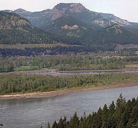
Table Mountain is a peak rising on the north side of the Columbia River in Washington state, about 4 miles (6.4 km) north-northwest of Bonneville Dam. It is one of the most spectacular landmarks of the Columbia River Gorge. Its southeast face drops 2,400 feet (730 m) in less than one horizontal mile (1.6 km.), and is topped by an almost vertical 800-foot (240 m) cliff. Table Mountain is joined by the similar Greenleaf Peak to the northeast, and also by Hamilton Mountain to the southwest, which is lower, (2,438 ft or 743 m), but similarly steep and much closer to the Columbia. Together these peaks form an impressive group on the Washington side of the Gorge.
Map of Table Mountain, Washington 98639, USA
Sometime between 1060 and 1760 AD the south side of Table Mountain sheared off and dammed the Columbia River in an event known as the Bonneville Slide. The river soon carved a new bend around to the south, but for a while Native Americans living in the area could walk across. This led to the legend known as the Bridge of the Gods.