Population 37,855 (Sep 2015) | Region Kantō - Tree Japanese black pine Area 37.98 km² Local time Tuesday 7:33 AM | |
 | ||
Weather 4°C, Wind NW at 21 km/h, 77% Humidity | ||
Tōkai (東海村, Tōkai-mura) is a village located in Naka District, Ibaraki Prefecture, in the northern Kantō region of Japan. As of September 2015, the village had an estimated population of 37,885 and a population density of 997 persons per km². Its total area was 37.98 km². The Japan Atomic Energy Agency along with other organizations currently operate a number of nuclear technology research facilities in the town. In particular, Tōkai Nuclear Power Plant is located in Tōkai.
Contents
- Map of Tokai Naka District Ibaraki Prefecture Japan
- Geography
- Surrounding municipalities
- History
- Economy
- Education
- Railway
- Highway
- Seaports
- International relations
- Noted people
- References
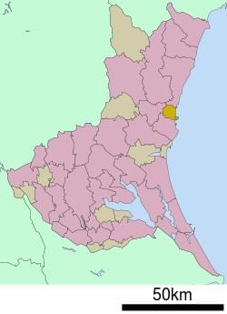
Map of Tokai, Naka District, Ibaraki Prefecture, Japan
Geography
Located in central Ibaraki Prefecture, approximately 120 kilometres (75 mi) north of Tokyo, Tōkai is bordered to the east by the Pacific Ocean.
Surrounding municipalities
History
The villages of Muramatsu and Ishigami were created with the establishment of the municipalities system on April 1, 1889. On March 31, 1955 the two villages merged to form the village of Tōkai. In 1956, Japan Atomic Energy Research Institute was established at Tōkai. The village was the site of the Tokaimura nuclear accident which occurred at the JCO nuclear reprocessing plant on 30 September 1999, which killed two people.
Economy
The nuclear power industry, together with associated government and private research facilities (including the J-PARC particle physics laboratory), and government subventions form the basis of the local economy.
Education
Tōkai has six elementary schools, two middle schools and one high school. In addition, the University of Tokyo and the Graduate University for Advanced Studies have research facilities located at Tōkai.
