
- summer (DST) CEST (UTC+2) Area 43.03 km² | Elevation 362 m Local time Monday 11:59 PM | |
 | ||
Weather 5°C, Wind NE at 3 km/h, 62% Humidity Points of interest Zámek Mitrowicz, Městské muzeum Týn nad, Semenec, Židova strouha, Muzeum Semenec | ||
T n nad vltavou povodn z de t 2 6 2016
Týn nad Vltavou ( [ˈtiːn ˈnad vl̩tavou̯]; German: Moldautein) is a town in the South Bohemian Region of the Czech Republic. It has approximately 8,200 inhabitants.
Contents
- T n nad vltavou povodn z de t 2 6 2016
- Map of 375 01 TC3BDn nad Vltavou Czechia
- M stsk plov rna t n nad vltavou
- History
- Main sights
- References
Map of 375 01 T%C3%BDn nad Vltavou, Czechia
M stsk plov rna t n nad vltavou
History
Until 1918, MOLDAUTHEIN - TYN NAD VLTAVOU was part of the Austrian monarchy (Austria side after the compromise of 1867), in the district with the same name, one of the 94 Bezirkshauptmannschaften in Bohemia.
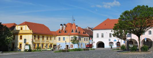
Main sights
References
Týn nad Vltavou Wikipedia(Text) CC BY-SA