
Time zone CET (UTC+1) Area 185.2 km² Local time Monday 11:18 PM Team Törökszentmiklósi KE | County Jász-Nagykun-Szolnok Postal code 5200 Population 23,145 (2002) Area code 56 | |
 | ||
Weather 6°C, Wind SW at 8 km/h, 53% Humidity | ||
Törökszentmiklós is a town in Jász-Nagykun-Szolnok county, in the Northern Great Plain region of central Hungary. It is the third-largest settlement in the county.
Contents
- Map of TC3B6rC3B6kszentmiklC3B3s Hungary
- Geography
- Timeline of the history of Trkszentmikls
- International relations
- References
Map of T%C3%B6r%C3%B6kszentmikl%C3%B3s, Hungary
Geography
It covers an area of 185.16 km2 (71 sq mi) and has a population of 23,145 people (2002).
Timeline of the history of Törökszentmiklós
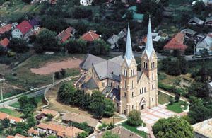
It is home to the Törökszentmiklós palace (shown in photo).
International relations
Törökszentmiklós is twinned with:
References
Törökszentmiklós Wikipedia(Text) CC BY-SA