
Country Vietnam Area 140 km2 | Province Tay Ninh Province | |
 | ||
Tây Ninh, Vietnam ( listen) is a provincial city in south-western Vietnam. It is the capital of Tây Ninh Province, which encompasses the town and much of the surrounding farmland. Tây Ninh is approximately 90 km to the northwest of Ho Chi Minh City, Vietnam's largest city. As of 2013, the city had a population of 153,537, and a total area of 140 km².
Contents
- Map of Ty Ninh
- Tay ninh city hoa thanh vietnam ql 22b 3 9 2017
- History
- Administrative division
- References
Map of Tây-Ninh
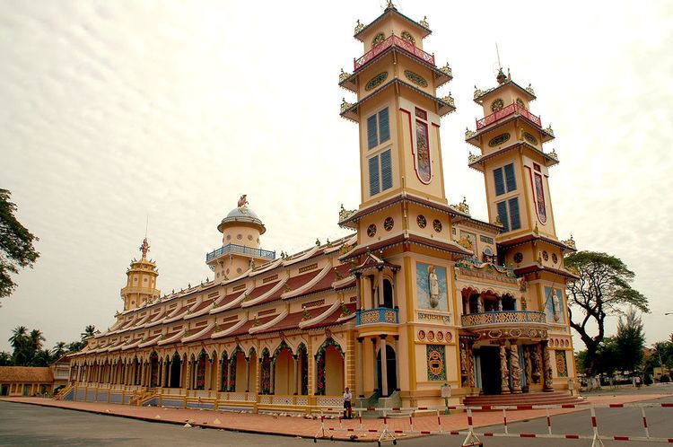
The city is most famous for being the home of the Cao Đài religion, an indigenous Vietnamese faith that includes the teachings of the major world religions. The Cao Đài religion's Holy See, built between 1933 and 1955, is located around 5 km to the east of Tây Ninh's city centre.
Apart from the Tay Ninh Holy See of the Cao Đài faith, there are other tourist attractions such as Black Virgin Mountain, and Dầu Tiếng Lake, one of the largest man-made lakes in Vietnam and Southeast Asia.
Tay ninh city hoa thanh vietnam ql 22b 3 9 2017
History
After the Fall of Saigon, the town of Tây Ninh was reorganized to comprise 3 wards and 1 commune. In August 2001, the town was expanded to include 5 wards and 5 communes. On 29 December 2013, Tây Ninh town was upgraded officially to provincial city status, under administration of Tây Ninh Province, along with the upgrade of its two communes Ninh Sơn and Ninh Thạnh to ward status.
Administrative division

Tây Ninh, Vietnam town comprises 7 wards (phường) and 3 communes (xã):
The ward is further divided into quarters (khu phố) and the commune into hamlets (ấp).