
- summer (DST) CEST (UTC+2) Postal code 35132 | Area 2.94 km² Municipality Hazlov | |
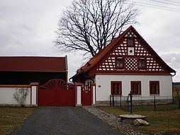 | ||
Táborská (German: Seichenreuth) is a village in Karlovy Vary Region, Czech Republic. It is one of the six municipality districts of Hazlov. In 2001 the village had a population of 13.
Contents
Map of T%C3%A1borsk%C3%A1, 352 01 Hazlov, Czechia
Geography
Táborská lies 3 kilometres southwest from Hazlov, about 535 meters above sea level. It is surrounded by forests. It neighbour with Polná to the northwest, with Libá to the southwest, with Ostroh to the southeast, with Poustka to the east and with Hazlov to the northeast.
History
Táborská was first mentioned in 1322. Oldest names of the village are; Sewkenrewt (1322), Seukenreuth, Schewkenrewt, Seikeinreit and Seiscenreit.
From 1869 to 1910, village was a part of municipality of Ostroh. In 1921, Táborská created an own municipality. Later was joined to Polná, and in 1961 was finally joined to Hazlov.