
Population 9,619 (2006 census) | Postcode(s) 2224 Postal code 2224 | |
 | ||
Location 22 km (14 mi) south of Sydney CBD | ||
Sylvania new south wales australia 4k ultra hd
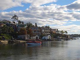
Sylvania is a suburb, in southern Sydney, in the state of New South Wales, Australia 22 kilometres south of the Sydney central business district in the Sutherland Shire.
Contents
- Sylvania new south wales australia 4k ultra hd
- Map of Sylvania NSW 2224 Australia
- History
- Commercial area
- Transport
- Schools
- Churches
- Population
- Notable residents
- References
Map of Sylvania NSW 2224, Australia
Sylvania is mostly residential but also contains areas of native bushland and some commercial developments on the Princes Highway and Port Hacking Road. Sylvania Heights is a locality in the western part of the suburb. Sylvania Waters and Kangaroo Point share the same postcode (2224).
History
The traditional owners of Sylvania are the Dharawal Aboriginal people and their archaeological heritage is evident in a number of registered middens, burial and art sites in rockshelters on the Georges River. After European settlement, this land was acquired by John Connell Laycock as a Crown grant. Thomas Holt (after whom Holt Road is named), a prominent landowner, financier and politician, acquired it a few years later as part of the Holt-Sutherland Estate, some 13,000 acres (53 km2). The name of the suburb clearly relates to its original wooded vegetation (‘sylvan’ which means wooded or inhabiting the woods). The native vegetation of the suburb is now fast disappearing, as a result of increased development. Thomas Holt built Sutherland House on the foreshore of Gwawley Bay in 1818, on the eastern side of Sylvania. He established the Sutherland Estate Company in 1881 and a village grew here, with a post office opening in 1883. The school opened in 1884 but closed in 1891 and was not reopened until 1925. Sylvania Heights Public School opened in 1955.
'Sutherland House' no longer stands (only its gate posts survive), but there are a number of heritage-listed buildings in the suburb. They include the original St Mark's timber church (now a Sylvania Public School class room) timber residence in Evelyn Street associated with the Holt Estate; 'Glenn Robin', built by William Glenn Wade on land he acquired in 1949 and completed in 1954; and 'Green Gables' built by Sidney and Clarisse Bayer between 1946 and 1952 on Kangaroo Point.*
In 1913 the 3 hectare area bounded by Florida Street, Harrow Street, Mowbray Street and Illawarra Road (now the Princes Highway) was known as the Swastika Estate.
Much of the land of Sylvania Waters was 'reclaimed' from Gwawley Bay, effectively destroying the highly integrated mangrove flora of the bay. Sylvania Waters Estate was developed by L.J.Hooker in the 1960s; land offered had water frontages with boating facilities. Streets were named after Australian rivers to emphasise the association with water, such as Shoalhaven, Tweed, Murrumbidgee, Hawkesbury and Barwon. The suburb has been identified as an area that is particularly vulnerable to inundation, should predictions of climate change, global warming and rising sea levels prove correct.
Commercial area
The Southgate Shopping Centre is located on the corner of the Princes Highway and Port Hacking Road. It contains two supermarkets Coles and Woolworths, a Kmart discount department store, many specialty shops including a post office, a bowling alley, a gymnasium, fast food restaurants and a pub. A small group of shops and restaurants is located on Princes Highway near the foot of Tom Uglys Bridge. Another group of shops is located further west along the Princes Highway at Sylvania Heights, which includes Sylvania Heights Plaza.
Transport
The Princes Highway crosses the Georges River over the Tom Uglys Bridge at Horse Rock Point and links Sylvania north to Blakehurst, in the St George area. The suburb is serviced by buses owned by the French-owned Transdev NSW company.
Schools
Churches
Population
According to the 2011Australian Bureau of Statistics Census of Population, there were 9,728 people usually resident in Sylvania. (This figure excludes Sylvania Waters, population 3,125 and Kangaroo Point, population 576.). 72.8% stated they were Australian-born. Of those born overseas, the percentages were as follows: England 3.3%, China (excluding Taiwan), New Zealand 1.6% and Greece 1.4%. English was stated as the only language spoken at home by 72.8% of residents and the most common other languages spoken were Greek 6.6%, Arabic 2.6% and Cantonese 2.5%. The most common responses for religion were Catholic 27.8%, Anglican 23.4%, No Religion 12.2%, Orthodox 12.0% and Uniting Church 4.1%.