
Grid reference TG208097 Location map English Nature Notification 1986 | Interest Biological Area of search Norfolk | |
 | ||
The Sweet Briar Road Meadows, Norwich is a Site of Special Scientific Interest SSSI located in the Wensum Valley within the boundary of Norwich in the English county of Norfolk. The site which was designated a SSSI in 1986 covers 23.55 acres (9.53 ha) is privately owned with no public access. But can be viewed from public paths which bound the site.
Contents
Description
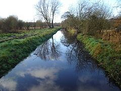
Enclosed between Norwich's outer ring road, industrial land and lying in the floodplain of the River Wensum the site acts as a 'green wedge' extending towards the city. The site consists of a series of unimproved wet meadows with permanent water-logging which support many plant species. Three principal grassland communities are present; damp neutral grassland, marshy grassland and areas of tall fen. A number of water-filled dykes bisect the site and attract large numbers of breeding amphibians in the spring months. Large flocks of redpoll and occasionally siskin feed on the alder trees that fringe the meadows. Many other bird species including snipe find the wet fields an ideal breeding habitat. The whole site is managed on traditional lines with light pony grazing without the use of artificial fertilizers and herbicides.
Location
Its western boundary is formed by the A140 outer ring road Sweet Briar Road. The Railway Path NCR1 lies to the north and the Riverside Walk in the south. Mile Cross Marsh together with the adjacent Sycamore Crescent Wood are known collectively as the Wensum Local Nature Reserve form the eastern boundary.