
Formation 1994 (1899) Purpose Water distribution | Type Municipal corporation | |
 | ||
Predecessor Deschutes Reclamation and Irrigation Company (DRIC) (1899) Founder (DRIC, 1899) Eight families of homesteaders including two families named Swalley | ||
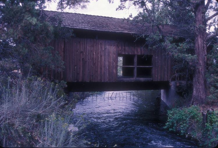
The Swalley Irrigation District supplies water to consumers through a network of pipes and canals fed by the Deschutes River near Bend in the U.S. state of Oregon. The network, begun in 1899, is a closed system with an intake behind North Canal Dam in Bend and a main canal, the Swalley Canal, that runs north from the city for about 13 miles (21 km). The only covered bridge east of the Cascade Range in Oregon crosses the Swalley Canal.
Contents
The district removes about 84 cubic feet per second (2.4 m3/s) from the river during the irrigation season, April through October. Water requirements for Swalley fell by 28 cubic feet per second (0.79 m3/s) after a conservation project completed in 2010. This amount remained in the river, where increased flow improved conditions for redband trout and other biological species. The project also added a small in-conduit turbine that generates electricity from water power.
History
The irrigation district was formed in 1899 as the Deschutes Reclamation and Irrigation Company (DRIC). In 1994, when shareholders in the company decided to incorporate as an irrigation district, they adopted the name Swalley Irrigation District after two resident families named Swalley who helped form and manage the DRIC. One of the Swalleys became the project leader and helped build the flumes that carried "Swalley water".
Description
The 17,000-acre (6,900 ha) district is about 14 miles (23 km) long and about 4 miles (6.4 km) wide. Its headworks at the North Canal Dam on the Deschutes River in Bend are at 3,558 feet (1,084 m) above sea level, and the water descends through pipes and open canals to farmland as much as 400 feet (0.12 km) lower.
The 13-mile (21 km) main canal, the Swalley Canal, and its network of 15 miles (24 km) of side canals, deliver water north of the city to about 700 customers. The district lies generally between U.S. Route 20 on the west and U.S. Route 97 on the east.
Water enters the system from behind the North Canal Dam on the Deschutes River in Bend. For its first 5.1 miles (8.2 km), the water flows through pressurized pipe. In 2010, the district completed the piping and the addition of an in-conduit 0.75-megawatt hydroelectric plant. The plant produces enough electricity to supply 375 homes. Annual income to the district from selling the electricity was estimated at between $160,000 and $190,000. Grants from other agencies had covered all but $2 million of the $14.5 million cost to build the plant, which has an expected lifespan of 50 to 100 years.
The canal delivers water another 7 miles (11 km) beyond the hydroelectric plant but does not discharge to a storage reservoir or any natural water body. It is a closed system. Screens prevent fish from entering the main canal at the headworks.
The average customer in the district receives enough water to irrigate 6 acres (2.4 ha). The most common crops are grass and alfalfa, and some customers use the water for oats, shrubs, pine trees, and other vegetation.
Conservation
The district began changing from open canals to pipes in the early 21st century to prevent water loss to leaks and evaporation. The 2010 project allowed 28 cubic feet per second (0.79 m3/s) of water to be subtracted from the Swalley District's allotment, which dropped to 84 cubic feet per second (2.4 m3/s). The increased flow along the Middle Deschutes improved conditions for life forms, such as the redband trout, that live in the river.
Earlier piping on lateral canals in the Swalley system and the nearby Central Oregon Irrigation District had already reduced diversions from the river totaling 6.6 cubic feet per second (0.19 m3/s) during the irrigation season, April through October. The goal of the Deschutes River Conservancy, which supported the projects, was to increase the minimum flow of the river below Bend from 30 to 100 cubic feet per second (0.8 to 2.8 m3/s). The piping proceeded despite objections from homeowners who unsuccessfully sued to keep the canal open on grounds that their property values would fall if the surface stream were replaced by a pipe.
Bridge
An unusual covered bridge spans the canal about 2 miles (3 km) north of Bend. The Rock O' the Range Bridge, the only covered bridge in Oregon that lies east of the Cascade Range, carries Bowery Lane over the canal. In 1963, a developer had the bridge built to provide access to his property. Land owners in the development pay to maintain the public bridge, one of only a few privately-funded covered bridges built in recent decades.
Coordinates
The Geographic Names Information System lists two sets of coordinates for the Swalley Canal. One is at 44°06′46″N 121°17′18″W in the Bend quadrant of the United States Geological Survey topographic map. The other is at 44°08′30″N 121°17′28″W in the Tumalo quadrant.
The coordinates for the head of the Swalley Canal are 44°04′32.06″N 121°18′22.06″W.
The coordinates for the covered bridge are 44°07′20.6″N 121°17′12.6″W.