
Elevation 460 m | Postal code 569 73 to 569 92 Area 13.89 km² | |
 | ||
Website | ||
Svojanov is a market town (městys) in Svitavy District in the Pardubice Region of the Czech Republic. Svojanov lies approximately 16 kilometres (10 mi) south of Svitavy, 65 km (40 mi) south-east of Pardubice, and 152 km (94 mi) east of Prague.
Map of Svojanov, Czechia
The town covers an area of 13.89 square kilometres (5.36 sq mi). From the total population of 389 (as of 1 January 2012), there are 214 women and 175 men. The number of inhabitants in the town has been decreasing over the last decades (for example in 1977 the town had 654 inhabitants).
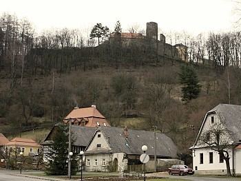
The town was firstly mentioned in 1287. It has a rich history that is closely connected with the Svojanov Castle. The castle was founded around 1262 by Ottokar II of Bohemia to protect the Trstenice route, a former trade route of significant importance. The castle's original German name was Fürstenberg. In 1421 the town was besieged by Jan Žižka and between 1642 and 1645 the town was occupied by the Swedes. In December 1798 the Russian legions marched through Svojanov to fight against Napoleon.
Starý Svojanov (English translation: Old Svojanov) is supposedly the oldest part of the municipality. An interesting sight is the church of St. Nicholas (Czech: kostel sv. Mikuláše) with a 13th-century chancel and fresco decoration which dates back to the period of Charles IV.