
Country United States County Oconto FIPS code 55-78725 Elevation 244 m Population 532 (2013) Area code 920 | Time zone Central (CST) (UTC-6) GNIS feature ID 1580561 Area 2.62 km² Local time Saturday 4:24 AM | |
 | ||
Weather -3°C, Wind S at 3 km/h, 81% Humidity | ||
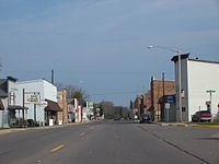
Suring is a village in Oconto County, Wisconsin, United States, along the 45th parallel. The population was 544 at the 2010 census. It is part of the Green Bay Metropolitan Statistical Area.
Contents
Map of Suring, WI, USA
History
A post office called Suring has been in operation since 1897. The village was named for J. Suring, a local landowner.
Geography
Suring is located at 45°0′0″N 88°22′28″W (45.000016, -88.374481).
According to the United States Census Bureau, the village has a total area of 1.01 square miles (2.62 km2), all of it land. The Oconto River and Peshtigo Brook define its boundaries on the Southwest.
The village stresses its location on the 45th parallel north with a marker, placing it halfway between the equator, and the north pole.
Wisconsin Highway 32, conjoined with County highway M, passes through the village.
2010 census
As of the census of 2010, there were 544 people, 232 households, and 133 families residing in the village. The population density was 538.6 inhabitants per square mile (208.0/km2). There were 268 housing units at an average density of 265.3 per square mile (102.4/km2). The racial makeup of the village was 90.4% White, 6.4% Native American, 0.9% from other races, and 2.2% from two or more races. Hispanic or Latino of any race were 1.7% of the population.
There were 232 households of which 31.9% had children under the age of 18 living with them, 39.2% were married couples living together, 14.7% had a female householder with no husband present, 3.4% had a male householder with no wife present, and 42.7% were non-families. 39.2% of all households were made up of individuals and 22.4% had someone living alone who was 65 years of age or older. The average household size was 2.17 and the average family size was 2.86.
The median age in the village was 43.2 years. 24.6% of residents were under the age of 18; 4.8% were between the ages of 18 and 24; 22.7% were from 25 to 44; 22.8% were from 45 to 64; and 25.2% were 65 years of age or older. The gender makeup of the village was 46.1% male and 53.9% female.
2000 census
As of the census of 2000, there were 605 people, 252 households, and 147 families residing in the village. The population density was 595.1 people per square mile (229.0/km²). There were 269 housing units at an average density of 264.6 per square mile (101.8/km²). The racial makeup of the village was 98.02% White, 0.17% African American, 1.32% Native American, 0.17% from other races, and 0.33% from two or more races. Hispanic or Latino of any race were 0.17% of the population.
There were 252 households out of which 29.8% had children under the age of 18, 43.7% were married couples living together, 9.9% had a female householder with no husband present, and 41.3% were non-families. 36.9% of all households were made up of individuals and 19.8% had someone living alone who was 65 years of age or older. The average household size was 2.17 and the average family size was 2.81.
In the village, the population was spread out with 22.6% under the age of 18, 8.6% from 18 to 24, 23.1% from 25 to 44, 18.0% from 45 to 64, and 27.6% who were 65 years of age or older. The median age was 42 years. For every 100 females there were 80.1 males. For every 100 females age 18 and over, there were 77.9 males.
The median income for a household in the village was $26,023, and the median income for a family was $38,125. Males had a median income of $28,182 versus $20,903 for females. The per capita income for the village was $14,230. About 10.5% of families and 12.4% of the population were below the poverty line, including 17.4% of those under age 18 and 9.3% of those age 65 or over.