
Peak Mus-Khaya Country Russia | Elevation 2,959 m (9,708 ft) | |
 | ||
Mountains Mus-Khaya Mountain, Berill Mountain | ||
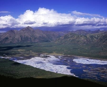
Suntar-Khayata Range (Russian: Сунтар-Хаята) is a granite mountain range rising along border of Sakha Republic in the north with Amur Oblast and Khabarovsk Krai in the south.
Contents
The highest point of the range is Mus-Khaya Mountain in Sakha Republic, 2959 m. Berill Mountain, 2933 m, is the highest in Khabarovsk Krai.
Suntar-Khayata Range is a watershed divide between the Aldan River, which eventually flows into the Lena River and the Arctic Ocean, and the Sea of Okhotsk. It contains the southernmost glaciers in the Russian Far East outside of Kamchatka, though its status is not known.
The range is approximately 450–550 km long and 60 km wide.
There are a sparse tree larch forests and tundra in higher on range's slopes.
Geology
The strata of this geological formation date back to the Late Jurassic. Dinosaur remains are among the fossils that have been recovered from the formation.
Vertebrate paleofauna
Indeterminate Carnosauria remains, possible indeterminate coelurosaur remains, indeterminate Sauropoda remains that had been previously referred to Camarasauridae indet, and indeterminate Theropoda remains have all been recovered from Suntar outcrops in Sakha Republic, Russia.