
Age of rock ~950 years Easiest route Hike Elevation 2,447 m | Mountain type Cinder cone Last eruption 1085 Prominence 340 m | |
 | ||
Topo map USGS Sunset Crater East Mountain range | ||
Sunset crater 02 plume height
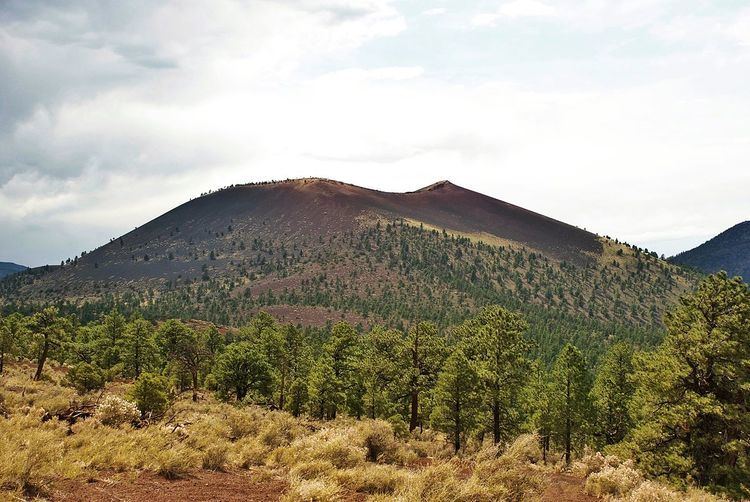
Sunset Crater is a cinder cone located north of Flagstaff in U.S. State of Arizona. The crater is within the Sunset Crater Volcano National Monument.
Contents
- Sunset crater 02 plume height
- Northern arizona walnut canyon sunset crater park
- 2015 eruption scareEdit
- Sunset Crater Volcano National MonumentEdit
- In popular cultureEdit
- References
Sunset Crater is the youngest in a string of volcanoes (the San Francisco volcanic field) that is related to the nearby San Francisco Peaks.
The date of the eruptions that formed the 340-meter-high cone (1,120 ft) was initially derived from tree-ring dates, suggesting the eruption began between the growing seasons of A.D. 1064–1065. However, more recent geologic and archaeological evidence places the eruption around A.D. 1085. The largest vent of the eruption, Sunset Crater itself, was the source of the Bonito and Kana-a lava flows that extended about 2.5 kilometers (1.6 mi) NW and 9.6 kilometers (6 mi) NE, respectively. Additional vents along a 10-kilometer-long fissure (6.2 mi) extending SE produced small spatter ramparts and a 6.4-kilometer-long lava flow (4 mi) to the east. The Sunset Crater eruption produced a blanket of ash and lapilli covering an area of more than 2,100 square kilometers (810 sq mi) and forced the temporary abandonment of settlements of the local Sinagua people. The volcano has partially revegetated, with pines and wildflowers. The crater is the namesake for the Sunset Crater Beardtongue (Penstemon clutei). Since the last eruption of the volcano is a recent occurrence, it is considered dormant by volcanologists.
Damage from hikers forced the National Park Service to close a trail leading to the crater, but a short trail at the base remains.
The hiking trail below the summit skirts the substantial Bonito Lava Flow. This hardened lava is black and appears fresh as it has devastated the forest in its path. The lava flow also created an ice cave or tube that is now closed to the public after a partial collapse.
Northern arizona walnut canyon sunset crater park
2015 eruption scareEdit
On June 5, 2015, a website with satellite images reported steam rising from the crater, leading to fears that Sunset Crater was erupting. The cause of the steam was later determined to be a forest fire, and geologists stated that the volcano was extinct.
Sunset Crater Volcano National MonumentEdit
Sunset Crater Volcano National Monument is a U.S. National Monument in the north-central part of the U.S. state of Arizona, created to protect Sunset Crater, a cinder cone within the San Francisco Volcanic Field. The monument is managed by the National Park Service in close conjunction with nearby Wupatki National Monument. In 1928, a Hollywood film company - Famous Players-Lasky Corporation - planned to detonate large quantities of explosives on the side of Sunset Crater in order to create an avalanche for Zane Grey's motion picture, Avalanche. Public outcry over this plan led in part to the proclamation of Sunset Crater Volcano National Monument by President Herbert Hoover in 1930.
A one-mile (1.6 km), self-guided loop trail is located at the base of Sunset Crater, but hiking to the summit is not permitted. A trail providing access to the summit and crater was closed in 1973 because of excessive erosion caused by hikers. A visitor center is located near the park entrance, 15 miles (24 km) north of Flagstaff, Arizona, along U.S. Highway 89.
In popular cultureEdit
In James Rollins' seventh Sigma Force novel The Devil Colony, Painter Crowe takes a contingent to explore Sunset Crater and the Wupatki National Monument. During the course of their preparations and explorations, the group discusses the history of the people and geology at the two sites.