
Population 1,043 (2006 census) Area 160 ha | Postcode(s) 6530 Postal code 6530 | |
 | ||
LGA(s) | ||
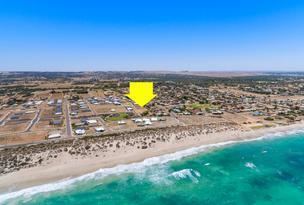
Sunset Beach is an outer northern coastal suburb of Geraldton, Western Australia. Its local government area is the City of Greater Geraldton.
Contents
Map of Sunset Beach WA 6530, Australia
The suburb was gazetted in 1977.
Geography
Sunset Beach is bounded by the Chapman River to the south, Chapman Road to the east and the Indian Ocean to the west.
Demographics
In the 2006 census, Sunset Beach had a population of 1,043.
Sunset Beach residents had a median age of 37, and median incomes were average for the Geraldton region — $473 per week compared with $461 per week. The population of Sunset Beach was predominantly Australian-born - 78.1% as at the 2006 census - and 4.5% of residents identified as Indigenous Australians. 5.18% were born in the United Kingdom.
The most popular religious affiliations in descending order in the 2006 census were Anglican, Roman Catholic, no religion and Uniting.