
FIPS code 06-75714 Elevation 37 m Zip code 93067 Area code Area code 805 | State California GNIS feature ID 1656637 Area 5.15 km² Population 1,448 (1 Apr 2010) | |
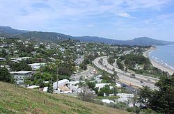 | ||
Summerland california dji phantom 3 drone footage
Summerland is a census designated place (CDP) in Santa Barbara County, California, United States. The population was 1,448 at the 2010 census, down from 1,545 at the 2000 census.
Contents
- Summerland california dji phantom 3 drone footage
- Map of Summerland CA USA
- History
- Geography
- Wildlife
- Climate
- 2010
- 2000
- In popular culture
- References
Map of Summerland, CA, USA
The town includes a school and a Presbyterian Church. There are many small businesses.
History
Tar from natural oil seeps in the Summerland area was long used as a sealant, both by the native Chumash peoples and by the Spanish builders of the Mission Santa Barbara, who used it as waterproofing for the roof. In 1883, spiritualist and real estate speculator H.L. Williams founded the town of Summerland. In 1888 he divided his land tract, on a moderately sloping hill facing the ocean, into numerous parcels. He promoted the tiny lots – 25 x 60 – to fellow Spiritualists, who bought them in quantity and moved to the area. The spiritual center of the town was a Spiritualist Church, with séance room, demolished only when Highway 101 was put through in the 1950s.
In the 1890s, oil development began in the coastal area of Summerland, at the Summerland Oil Field. Numerous wooden oil derricks were built on the beach, and on piers stretching into the ocean. The world's first offshore oil well, drilled into the sea floor, was at this location. Production at this beach area peaked before 1910, although most of the rigs remained into the 1920s. Peak production from the onshore portion of the Summerland Field did not actually occur until 1930; the last oil was pumped from the nearshore region in 1940. In 1957, Standard Oil Co. of California (now Chevron) found the large Summerland Offshore Oil Field, several miles offshore, which was shut down in the 1990s.
In January 1969, a blowout at the Dos Cuadras Field, about five miles offshore, caused the Santa Barbara Oil Spill, a formative event for the modern environmental movement.
In August 2015, Summerland's beach was closed for several days by County of Santa Barbara health officials due to large amounts of oil washed onshore. Local residents suspect the petroleum source is a leaking capped oil well ("the Becker wellhead") in the tidal area below Lookout Park.
Summerland was the home of artist Julian Ritter, who lived on Torito Rd.
Geography
Summerland is located at 34°25′17″N 119°35′45″W (34.421395, -119.595969). It is on the coast directly east at Ortega Ridge Road at the unincorporated community of Montecito and west-northwest of the city of Carpinteria. Summerland has a significantly higher population density than the surrounding area. U.S. Route 101 goes through Summerland.
According to the United States Census Bureau, the CDP has a total area of 2.0 square miles (5.2 km²), of which, 2.0 square miles (5.1 km²) of it is land and 0.33% is water.
The community is built on a set of coastal bluffs right next to the ocean. Surrounding it and Montecito are the cities of Carpinteria and Santa Barbara.
Wildlife
Raccoons, skunks, and foxes appear in yards. In the wild, there are bobcats, coyotes, mountain lions, and American black bears.
Climate
This region experiences warm (but not hot) and dry summers, with no average monthly temperatures above 71.6 °F. According to the Köppen Climate Classification system, Summerland has a warm-summer Mediterranean climate, abbreviated "Csb" on climate maps.
2010
The 2010 United States Census reported that Summerland had a population of 1,448. The population density was 727.9 people per square mile (281.1/km²). The racial makeup of Summerland was 1,295 (89.4%) White, 3 (0.2%) African American, 7 (0.5%) Native American, 41 (2.8%) Asian, 6 (0.4%) Pacific Islander, 51 (3.5%) from other races, and 45 (3.1%) from two or more races. Hispanic or Latino of any race were 192 persons (13.3%).
The Census reported that 1,448 people (100% of the population) lived in households, 0 (0%) lived in non-institutionalized group quarters, and 0 (0%) were institutionalized.
There were 687 households, out of which 128 (18.6%) had children under the age of 18 living in them, 270 (39.3%) were opposite-sex married couples living together, 55 (8.0%) had a female householder with no husband present, 23 (3.3%) had a male householder with no wife present. There were 54 (7.9%) unmarried opposite-sex partnerships, and 9 (1.3%) same-sex married couples or partnerships. 230 households (33.5%) were made up of individuals and 62 (9.0%) had someone living alone who was 65 years of age or older. The average household size was 2.11. There were 348 families (50.7% of all households); the average family size was 2.68.
The population was spread out with 211 people (14.6%) under the age of 18, 119 people (8.2%) aged 18 to 24, 315 people (21.8%) aged 25 to 44, 546 people (37.7%) aged 45 to 64, and 257 people (17.7%) who were 65 years of age or older. The median age was 49.2 years. For every 100 females there were 92.0 males. For every 100 females age 18 and over, there were 88.6 males.
There were 823 housing units at an average density of 413.7 per square mile (159.7/km²), of which 362 (52.7%) were owner-occupied, and 325 (47.3%) were occupied by renters. The homeowner vacancy rate was 3.2%; the rental vacancy rate was 9.7%. 790 people (54.6% of the population) lived in owner-occupied housing units and 658 people (45.4%) lived in rental housing units.
2000
As of the census of 2000, there were 1,545 people, 715 households, and 368 families residing in the CDP. The population density was 764.7 people per square mile (295.3/km²). There were 784 housing units at an average density of 388.0 per square mile (149.9/km²). The racial makeup of the CDP was 91.78% White, 0.45% African American, 0.26% Native American, 2.39% Asian, 0.13% Pacific Islander, 2.27% from other races, and 2.72% from two or more races. Hispanic or Latino of any race were 7.44% of the population.
There were 715 households out of which 17.9% had children under the age of 18 living with them, 42.2% were married couples living together, 7.4% had a female householder with no husband present, and 48.5% were non-families. 33.1% of all households were made up of individuals and 5.5% had someone living alone who was 65 years of age or older. The average household size was 2.16 and the average family size was 2.70.
In the CDP, the population was spread out with 14.6% under the age of 18, 6.7% from 18 to 24, 34.2% from 25 to 44, 32.9% from 45 to 64, and 11.7% who were 65 years of age or older. The median age was 42 years. For every 100 females there were 93.9 males. For every 100 females age 18 and over, there were 91.9 males.
The median income for a household in the CDP was $53,964, and the median income for a family was $75,625. Males had a median income of $50,469 versus $41,042 for females. The per capita income for the CDP was $41,668. About 4.5% of families and 9.5% of the population were below the poverty line, including 7.5% of those under age 18 and none of those age 65 or over.