
Max. length 28 kilometres (17 mi) Max. depth 376 metres (1,234 ft) Area 27.53 km² Shore length 69.43 km | Surface area 28 km (11 sq mi) Surface elevation 69 m Volume 4.49 km³ | |
 | ||
Max. width 1.8 kilometres (1.1 mi) | ||
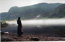
Suldalsvatnet is the 6th deepest lake in Norway. The 376-metre (1,234 ft) deep lake lies in the municipality of Suldal in Rogaland county, Norway. The 28-square-kilometre (11 sq mi) lake is the headwaters of the river Suldalslågen and it sits at an elevation of 69 metres (226 ft) above sea level. The lake has a volume of 4.49 cubic kilometres (1.08 cu mi).
Map of Suldalsvatnet, Suldal Municipality, Norway
The 28-kilometre (17 mi) long lake is regulated for use in two nearby hydroelectric power plants.
References
Suldalsvatnet Wikipedia(Text) CC BY-SA