
Council Bustan al-Marj | Population (2015) 2,467 | |
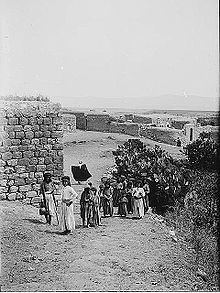 | ||
Sulam (Arabic: سولم; Hebrew: סוּלַם) is an Arab village in north-eastern Israel. Known in ancient times as Shunama and Shunem, it is first mentioned in the Amarna Letters in the 14th century BCE. Archaeological excavations in the village attest to habitation extending from the Bronze Age through to modern times. Located near Afula, it falls under the jurisdiction of Bustan al-Marj Regional Council. In 2015 it had a population of 2,467.
Contents
Map of Sulam, Israel
History
In the Amarna letters, 14th century BCE clay tablets written in the cuneiform script of the Akkadian language, the village is listed under its ancient name of Shunama, as one of several cities conquered by the Canaanite warlord Lab'ayu in the Dothan Valley and southern Jezreel Valley. Sulam is also identified with the biblical village of Shunem, which is said to be of the tribe of Issachar and the place where the Philistines camped before Saul's last battle, and the native town of Abishag, King David's concubine, in 1Kings 1,1.
Mentioned by the name Sulem in 4th century CE works, such as the Onomasticon of Eusebius, and by Jerome, both authors situate it 5 Roman miles from Tabor. The village was also known to the Crusaders (12th century CE) under the name Suna.
Ottoman era
During the period of Ottoman rule, Sulam was listed in the Ottoman tax registers of 1596 as being in the nahiya of Jinin in the liwa of Lajjun. It had a population of 26 Muslim families.
Pierre Jacotin named the village Soulin on his map from 1799. Edward Robinson and Eli Smith, who visited the village in 1838, describe it as "small and dirty" and its inhabitants as "civil and friendly." They also recount being approached by the Wely of Duhy who offered to take them to the shrine on the mountain which he said was often visited by monks.
In 1882 the Palestine Exploration Fund's Survey of Western Palestine (SWP) describes Sulam as, "a large village, standing on a slope near the foot of Jebel ed Duhy ["Mountain of Duhy"]." It further notes that part of the village was built of stone, and that to the west there were shady gardens of lemon-trees. A perennial spring in the west collected in a stone trough was said to have good supply of clear water in September, 1872. What was described as a suburb of mud hovels ran southwards out from the village.
British Mandate era
In the 1922 census of Palestine conducted by the British authorities, Suolam had a population of 370; 366 Muslims and 4 Christians, decreasing in the 1931 census to 328, all Muslim, in a total of 85 houses.
In 1945 the population was 470, all Arabs, while the total land area was 3,605 dunams, according to an official land and population survey. Of this, 4 dunams were allocated for citrus and bananas, 291 for plantations and irrigable land, 2,041 for cereals, while 17 dunams were classified as built-up areas.
Archaeological excavations
The village is situated on and around an archaeological tell and developed around the spring. During the construction of a new house in the village in the early 21st century, ancient ruins were exposed. A salvage excavation was undertaken in February 2004 that uncovered strata dated to the Early Bronze Age and the Roman period. In a single square (4 × 6 meters), excavated to a depth of 1 meter, that had previously been covered by 1.5 meters of sterile alluvial soil, remains dated to the Bronze Age included part of stone building and potsherds, while the Roman period remains included potsherds, coins, animal bones, and marble fragments. Two coins were dated to the Byzantine period (2nd half of the 6th century CE), one of which was an Arab-Byzantine coin (c. 640-660 CE) that imitates the coins of emperor Constans II.
A follow-up excavation in an adjacent 4 x 4 meter area conducted in August 2007 discovered potsherds from the Iron Age, as well as those dated to the Byzantine period, or the beginning of the Early Islamic period.
A salvage excavation undertaken at the southern end of the village in August 2003 uncovered a tabun oven and fragments of pottery that were dated to Early Islamic period, specifically to the period of early Abbasid rule. Additional attestation to the village being inhabited during the period of Mamluk rule over Palestine, was found in the form of a wall and living space uncovered during salvage excavations undertaken in a private home in Sulam in August 2006. Other remains discovered in the village include a church, hiding complexes, and tombs.
Another excavation undertaken on the main street of the village at the end of 2007, uncovered building remains from the Early Islamic period (8th-10th centuries) and the late Ottoman period (19th century), as well as a burnt layer from the end of the Crusader and beginning of the Mamluk periods (12th-13th centuries). It also revealed potsherds from the Iron Age, Hellenistic, Byzantine and Roman periods. The Israeli archaeology report on this excavation indicated that the core of the village had been destroyed and rebuilt many times over the years, and that there was a hiatus in settlement between the 13th and 19th centuries. Another Israeli excavation report from December 2006 uncovered remains from the periods of Roman (3rd century), Byzantine, Early Islamic, Crusader (12th century), Mamluk (13th-15th centuries), and Ottoman (17th-19th centuries) rule.