
Listing Graham, Marilyn Topo map OS Landranger 15 Prominence 496 m | OS grid NC153183 Elevation 731 m | |
 | ||
Pronunciation Scottish Gaelic: [ˈsulə vjeɲ] Similar Stac Pollaidh, Canisp, Cùl Mòr, Quinag, Cùl Beag | ||
Suilven scotland the world s coolest mountain by dji phantom 3 quadcopter drone
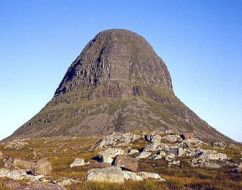
Suilven (Scottish Gaelic: Sula Bheinn) is one of the most distinctive mountains in Scotland. Lying in a remote area in the west of Sutherland, it rises almost vertically from a wilderness landscape of moorland, bogs and lochans known as Inverpolly National Nature Reserve.
Contents
- Suilven scotland the world s coolest mountain by dji phantom 3 quadcopter drone
- Map of Suilven Lairg UK
- Majestic suilven canisp highland scotland from the air by drone
- AscentEdit
- References
Map of Suilven, Lairg, UK
Suilven forms a steep-sided ridge some 2 km in length. The highest point, known as Caisteal Liath (the Grey Castle in Scottish Gaelic), lies at the northwest end of this ridge. There are two other summits: Meall Meadhonach (Middle Round Hill) at the central point of the ridge is 723 m high, whilst Meall Beag (Little Round Hill) lies at the southeastern end.
Geologically, Suilven is formed of Torridonian sandstone, sitting on a landscape of Lewisian Gneiss. The surrounding rocks were eroded during an episode of glaciation. Suilven was left poking above the level of the ice sheet, as a nunatak, with the flow of ice creating the distinctive narrow teardrop plan, while carving and scouring the vertical sides of the mountain.
From the coast to the west Suilven looks like a large grey pillar, hence the name which it was given by sea-borne Vikings. From the inland side the mountain has more of the appearance of a steeply-sided pyramid.
In 2005 Glencanisp estate, of which Suilven forms part and the neighbouring Drumrunie estate, were bought by the local community with the help of the John Muir Trust. The Assynt Foundation aims to create local employment and safeguard the natural and cultural heritage for the benefit of the community and future generations, and for the enjoyment of the wider public.
Majestic suilven canisp highland scotland from the air by drone
AscentEdit
The most common route of ascent starts from the end of the public road that leads to Glencanisp Lodge, about 1.5 km from Lochinver to the west of the summit. From here a path leads across undulating moorland toward the mountain, which will be seen clearly ahead. About 6 km after leaving the road, and shortly after crossing Abhainn na Clach Àirigh (a river), a cairn marks the spot where one should leave the path. A boggy path leads towards Suilven, reaching Bealach Mòr (the Great Bealach) after a little over 2 km. The final pull up to the bealach is steep, and the path is much eroded, but from here the summit is easily attained. The summit itself is broad and grassy, though it is almost totally surrounded by vertical cliffs.
Another route starts from Inverkirkaig, some 4 km south of Lochinver: this route reaches the bealach from the south, passing Kirkaig Falls on the way. One may also start from Elphin, on the eastern side. It is possible to reach the ridge without first climbing to Bealach Mòr from this direction, though very exposed scrambling is required, particularly between Meall Meadhonach and Meall Beag.
By Scottish standards all routes to Suilven are long days; all are around 25 km in length over rough terrain.