
Population 36 (2001) Civil parish Stretton en le Field Local time Wednesday 12:17 PM | OS grid reference SK304119 Sovereign state United Kingdom Dialling code 01530 | |
 | ||
Weather 13°C, Wind S at 19 km/h, 81% Humidity | ||
Stretton en le Field is a small village and civil parish in the North West Leicestershire district of Leicestershire, England. It is about seven miles (11 km) south-west of Ashby de la Zouch, and according to the 2001 census the parish had a population of 36. At the 2011 census the population remained less than 100 and is included in the civil parish of Chilcote.
Contents
- Map of Stretton en le Field Swadlincote UK
- Roman origins
- Domesday
- Medieval history
- 19th century
- References
Map of Stretton en le Field, Swadlincote, UK
Stretton Bridge carries the A444 road across the River Mease, which forms this small parish's northern boundary.
Stretton en le Field is one of the Thankful Villages having suffered no fatalities in the Great War of 1914-18 when eleven men went from the village to fight and all eleven returned.
Roman origins
The name Stretton-en-le-Field is explained as a settlement ton/tun, lying in open country field/feld, by a Roman road stret/straet; with the influence of French on English history following the Norman Conquest having a clear impact on the village's current name.
Of the seventeen Strettons in England, all but two are situated on Roman Roads; the Roman road from which the village gains its name, however, has not yet been positively identified. Evidence supports that both the A444 (Nuneaton-Burton Upon Trent) and the Tamworth Road (formerly the A453; Tamworth-Ashby-De-La-Zouch) were used by the Romans. Although the A444 passes closest to the village, the straightness Tamworth Road suggest it was the Straet the village gained its name from.
The remains of two Roman buildings have been found on the boundary between Stretton and the neighbouring parish of Appleby Magna. Archaeological excavations done in advance of the construction of a hotel at the M42/A444 junction revealed the remains of a 4th-century farm. Roman coins were found on the site from the reigns of Emperor Constantine I (307-337) and Emperor Magnentius (350-353), as well as 4th-century pottery and roof-tiles. The farm buildings included a corn-drying oven, sunken buildings containing chaff from threshing and fragments of quern-stones. Other finds include a corroded iron knife-blade, copper alloy pins, an iron hobnail, and animal bones including those of cattle, sheep, pigs, dogs and cats. The site was completely destroyed with the construction of the Appleby Park Hotel; the hotel itself is to be demolished to make way for the HS2 railway between Birmingham and Sheffield. This farm is thought to have sat adjacent to a Roman Villa; The Old Rectory, also in Appleby Magna is thought to have been constructed on these remains. The adjacent road, Rectory Lane, was previously known as The Golden Way Road, and before that as Goldherewey/Goldhordewe, referring to a hoard of Roman coins found there in medieval times.
Domesday
Although currently in Leicestershire, Stretton was historically part of Derbyshire; the village has passed between the two several times and the parish has straddled, at various times, the boundary between the two counties. The Domesday book has two listings for Stretton: one part in Leicestershire, one in Derbyshire; both belonging to Henry de Ferrers as tenant-in-chief.
The Leicestershire manor is listed as worth £0.1, with a taxable value of 3 geld units. The Lord is recorded as Roger of Livet (having previously been Aelfric of Bradbourne, Kari, and Leofnoth Sterre in 1066).
The Derbyshire manor is the larger, and is listed as containing a mill, and 10 acres (40,000 m2) of meadow, and was home to Four households. The manor was valued at £0.8, with a taxable value of 1 geld unit; the Lord is also Roger of Livet (it was Aelfric of Bradbourne in 1066).
Medieval history
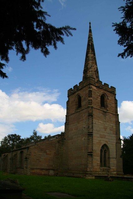
The Village's church, St Michael's Church, was constructed in the 14th century in an elevated position in the village; although it is currently redundant and not used for regular services, it remains a consecrated building: it is Grade II* Listed and is maintained by the Churches Conservation Trust. It is considered historically valuable as (with the exception of new box pews in the 18th century) the church has remained unchanged since medieval times.
19th century
The village used to be considerably larger than it is currently; the decline in population recognized as early as the 1830s. In 1801 the village had a population of 212. By 1831 this had fallen to 109. In the 1891 census, the population had fallen further to 70. The village and parish (which includes outlying farms and houses) are estimated to have a current population of 36.
Earthworks near to the church reveal the location of the former buildings of the village, as well as Stretton Hall, formerly home to the Lord of the Manor.
In 1835 the parish extended to 1000 acres of what was described as "very rich land, mostly arable", and the village was described as "neat and pleasant". The Lord of the manor was Sir John Robert Cave-Browne-Cave, 10th Baronet Cave-Browne-Cave (1798–1855), who lived in Stretton Hall, which as described as "a handsome mansion, occupies a picturesque an romantic situation, with fine views of the country around". By 1891 Stretton Hall had passed to Sir Myles Cave-Browne-Cave, 11th Baronet Cave-Browne-Cave (1822–1907) who is described as the principal landowner in the parish. Stretton Hall is described as "an ancient mansion near the church and surrounded by a shrubbery". After Sir Myles death, the title passed to his second son Genille (his eldest having previously died); Sir Genille Cave-Browne-Cave, 12th Baronet (1869–1929), before inheriting his father's title and fortune, had worked in America as a bartender and cowboy (using the assumed name "Mr. Harrison". The New York Times stated Sir Genille's inheritance was 6,000 acres; the article, however, seems inaccurate, describing the Stretton Hall as "A Norman Castle with accommodation for sixty guests, and a stable that quarters forty horses". After having been used during World War II to billet soldiers and then to house Italian prisoners of war, Stretton Hall was demolished in c. 1945.
In 1897, boundary changes transferred Stretton En Le Field from Derbyshire into Leicestershire; where it remains today.