
Population 1,109 (22011 census) Time zone AEST (UTC+10) | Established 1877 County Nares Elevation 5 m | |
 | ||
Location 1,707 km (1,061 mi) NW of Brisbane2,420 km (1,504 mi) NNW of Sydney6.8 km (4 mi) NNW of Cairns CBD | ||
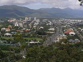
Stratford is a suburb of Cairns in the Cairns Region, Queensland, Australia. In the 2011 census, Stratford had a population of 1,109 people.
Contents
Map of Stratford QLD 4870, Australia
Geography
Stratford is 6.8 kilometres (4.2 mi) NNW of the Cairns CBD. It is bounded to the north by the Barron River. It is bounded to the east by the Captain Cook Highway. The northern part of the suburb is situated on the lower slopes (10–40 metres above sea level) of Mount Whitfield and Lumley Hill and is used for residential housing. The southern part of the suburb is undeveloped dense bushland on the higher slopes rising to about 160 metres.
Amenities
There are several restaurants, a pub, The Barron River Hotel, a service station, a newsagent, convenience store, launderette, a pizza shop, medical center, pharmacy and deli.
History
In the 2006 census, Stratford had a population of 1,178 people.
Heritage listings
Stratford has a number of heritage-listed sites, including: