
 | ||
Strandflat is the low land on the coast and the near coast bottom of sea, typical for the landscape of the Norwegian coast. This landform is created in the Quaternary Period, and it is only to be found in arctic and antarctic areas that has been or is covered by ice, for instance Greenland and Svalbard. Strandflat is a geomorphological word of Norwegian origin, and is used in geology and geography.
Contents
Characteristics
The strandflat includes areas on land as well as in the sea, and might be separated in three zones: Outmost is a submarine zone, thereafter a skerry zone and innermost a supramarine zone. The strandflat ends against a steep rock on the land side, even higher mountains, and in the sea side the strandflat ends with a steep slope down to the continental shelf. The strandflat is near to the sea level of today; the areas on land side reach no more than 50 m., and the areas in sea is commonly not more than 50 m deep. The width of strandflat varies from 50 – 60 km to nearly nothing. The strandflat is a location for lots of special mountains, they are called rauk. They have one common characteristic, they are all very steep. The rauks are landmarks on the Norwegian coast.
The term strandflat
The word was introduced year 1894 by the Norwegian geologist Hans Reusch. The Norwegian coast is a model area of the geomorphological description of the strandflat. Researchers have tried to explain how the strandflat landscape has evolved, inter alia the Norwegians Nansen, Holtedahl and Klemsdal.
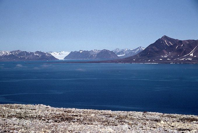
Creating the strandflat
As a landform the strandflat is in a context of ocean and the level of the ocean. The erosion of waves and glaciers as well as frost weathering has been the most important suggestions to explain how the strandflat has occurred.
Frost weathering and processes involving ocean ice was the most important forces creating the strandflat. This process is still going on and can be observed at Svalbard. An important moment is that strandflat only are found in areas that earlier was covered by ice. In cold areas ocean ice are able to cover the coast as a package. Stones, gravel and sand, as well as boulders, may freeze under the ice, and thereafter be broken off the land and transported away. The tide was able to lift these ice-packages and the water stream moved them away. This is a process that were functioning in the shoreline, where the tide is running. Wave erosion and glaciers had only a minor role in the creating the strandflat.