
Surface elevation 978 m | Catchment area 268.7 km² | |
 | ||
Strandavatnet is a lake in Hol municipality, Norway. The lake covers an area of 23.75 square kilometres (9.17 sq mi), and lies 975 metres (3,199 ft) above sea level.' The lake is a reservoir for the Rud hydroelectric powerstation in Hovet, Buskerud. In 1952/1953 a dam was constructed which lifted the lake level 28 meters, thus the lake varies between 950 and 978 m above sea level.
Contents
Map of Strandavatnet, 3577 Hovet, Norway
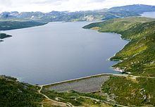
First rock filling dam in Norway
The dam in the Strandavatnet was the first rock filling (embankment) dam in Norway. You can see the dam on your left hand side from FV 50 at Myrland (the road to Raggsteindalen goes over the dam). The Hol 1 power station, in Hovet, Buskerud utilizes water from two watercourses, Urunda, where Strandavatnet, is the intake reservoir, and Votna where Varaldset is the intake reservoir. Stolsvatnet is the biggest and highest reservoir in the Votna watercourse. See figure below.