
Population 192 (in 2011) Civil parish Stourton with Gasper Region South West Local time Tuesday 9:42 PM Ceremonial county Wiltshire UK parliament constituency South West Wiltshire | OS grid reference ST778341 Unitary authority Country England Dialling code 01747 Post town Warminster | |
 | ||
Weather 10°C, Wind S at 18 km/h, 94% Humidity | ||
Stourton is a village in Wiltshire, England. The village is close to the county boundary with Somerset and about 8.5 miles (13.7 km) south of the Somerset market town of Frome. It is part of the Stourhead estate, now in the ownership of the National Trust.
Contents
Map of Stourton, Warminster, UK
Two miles south-west are the earthwork remains of a motte-and-bailey castle known as Castle Orchard.
Civil parish
The civil parish of Stourton with Gasper consists of three ancient manors: Stourton, Bonham and Gasper. The hamlets of Bonham and Gasper were in the Norton Ferris Hundred of Somerset until 1895, when a boundary revision transferred the Somerset portion of the parish to Wiltshire.
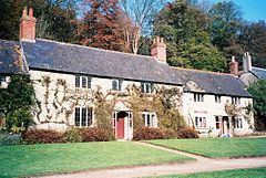
Buildings
The Church of England parish church of St Peter has 14th-century origins but has been much restored and altered; it is Grade I listed. It contains monuments of the Hoare family, owners of the estate. The architect and mason Nathaniel Ireson was churchwarden in the 1720s and may have done work on the church himself. The antiquarian William Coxe was rector from 1801 to 1811.
Bonham House and cottage are also from the 14th century and are Grade II* listed. A Roman Catholic chapel was here from 1559 until 1950.
Amenities
There is a village hall and a pub, the Spread Eagle Inn.
Stourton is home to Kilmington and Stourton Cricket Club who play in Division One of the Somerset Cricket League.