
Population 617 Civil parish Stourpaine | OS grid reference ST861093 Sovereign state United Kingdom Local time Tuesday 9:41 PM Dialling code 01258 | |
 | ||
Weather 11°C, Wind S at 18 km/h, 93% Humidity | ||
North dorset trailway walks blandford forum to stourpaine
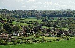
Stourpaine (/staʊərˈpeɪn/ stowr-PAYN) is a village and civil parish in the county of Dorset in southern England. It is situated in the valley of the River Stour in the North Dorset administrative district, 3 miles (4.8 km) northwest of Blandford Forum. The A350 road, which connects Blandford to Shaftesbury to the north, passes through the village. The chalk hills of Cranborne Chase and the Dorset Downs lie immediately to the north-east and south-west respectively. In the 2011 census the civil parish had 277 dwellings, 265 households and a population of 617.
Contents
- North dorset trailway walks blandford forum to stourpaine
- Map of Stourpaine Blandford Forum UK
- References
Map of Stourpaine, Blandford Forum, UK
References
Stourpaine Wikipedia(Text) CC BY-SA