Population 314 (2011) | Sovereign state United Kingdom Postcode district IP23 | |
 | ||
Stoke Ash is a village and civil parish in the Mid Suffolk district of Suffolk in eastern England. Located around six miles south of Diss, in 2011 its population was 314. The village shares a parish council with neighbouring Thwaite. It is located on the road from London to Norwich. The name 'Stoke', comes from 'stoc', which means a place or a secondary settlement in old English. The word 'Ash', comes from the Anglian word 'æsc', which means ash-tree. The name Ash was added to the name Stoke in the sixteenth century. In 1086 Stoke Ash was known as Stoches Stotas.
Contents
Map of Stoke Ash, UK
Early history
There is evidence of Roman settlement in Stoke Ash. A collection of Roman coins and pottery pieces have been found in the area. There is a small Roman site located "on the Colchester to Caistor Roman road". There are Roman tiles in the wall of the tower over the doorway in the All Saints Church. Some military items and pieces of overseas household articles have also been found.
History
In 1801, the population was divided into "those 'chiefly employed in agriculture', those 'chiefly employed in trade, manufacturers or handicraft', and others." In 1831, 56 percent of the population were labourers and servants. Twenty percent were the middle class and 15 percent were employers and professionals. Only 2 percent was classed as 'other'. Kelly's Directory of Suffolk (1900), described the soil as being mixed, consisting of subsoil and clay. The chief crops were wheat, barley and beans. The area was said to be 1,200 acres. The Parish School, which included both girls and boys, consisted of 50 children, with an average attendance of 47. The pie chart shows the social status of men above the age of 20 in the year 1831. The "middle sorts" are a combination of farmers who do not pay for labourers and masters and skilled workers in urban manufacturing and handicrafts.
Present Day
The village consists of a church called All Saints, a village hall and green, a post office and a public house called the White Horse Inn. The A140 splits the village into two. To the east of the A140 are most of the houses, the church, village halls and post office, making this area the main part of the village. The Baptist church and six more homes are situated to the north of the village. The primary school and the White Horse Inn are located on the west side of the A140.
The average population is older than the national average of the UK and also that of Suffolk. According to the UK 2011 Census, Stoke Ash does not have a large immigrant population as it has a low rate of inhabitants born in other EU countries or outside the EU. It has a higher level of residents born in the UK than the national average. The residents stating their health as 'very good' in the 2011 UK census was higher than the national average. The residents stating their health as 'very bad' was lower than the national average which suggests that people in Stoke Ash are generally more satisfied with their health than the average person in the UK. Stoke Ash has a higher rate of home ownership, either completely or on contract compared to the national average, which suggests that Stoke Ash is a relatively wealthy place. The pie chart shows the occupational statistics of 2011. Almost all the main jobs in 2011 have an equal amount of people working in those sectors. This shows social structure has improved drastically because in 1831 most people were servants.
All Saints Church
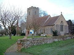
All Saints is a medieval church located on Church Lane in Stoke Ash. It was founded in 1538 and includes a cemetery. It was intensely renewed in 1868. It is a Norman building made of flint and stone, consisting of S porch, chancel, nave and a square embattled western tower. The late fourteenth century square tower has a defensive wall and the roof is made of concrete brick tiles. The western tower accommodates four bells. The church has a Tudor red-brick porch. The west doorway and the tower stair doorway are both the original doors. The Arms of William IV (1836) are located above the south doorway. There are around 150 seats in the Church. The benches are from the year 1868. The register dates back from the year 1550.
The White Horse Inn
The White Horse Inn is a bed and breakfast which is situated on the A140 close to the town of Eye in Suffolk which is midway between Ipswich and Norwich. It dates back to 17th century when it was a Coaching Inn. It was built when Charles the 1st ruled, and was completed two years before he was beheaded. During this time the Inn was used for many different things, such as a farm house, coaching inn, a public house and a roadside café. There have been reconstructions to the inn but the fireplace is original. It has hardly been used since its first owners needed it for light, heat and cooking. When it was a coaching inn, barns surrounded the building where horses were kept. In the 19th Century the Inn was the location for hiring servants.
