
Surface area 1.1 km (0.42 sq mi) Area 110 ha | Water volume 5.205 million m³ | |
 | ||
Basin countries England, United Kingdom | ||
Kayak trip stithians reservoir and dam in the sunset cornwall uk
Stithians Reservoir is a reservoir situated just under a mile to the west of the village of Stithians, Cornwall, England, UK.
Contents
- Kayak trip stithians reservoir and dam in the sunset cornwall uk
- Map of Stithians Reservoir United Kingdom
- HistoryEdit
- StatisticsEdit
- UsageEdit
- References
Map of Stithians Reservoir, United Kingdom
HistoryEdit
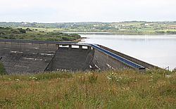
Work on the dam began on 19 July 1962, however work stopped shortly after due to excavations which revealed the site was over a large area of soft kaolinised granite, which would require expensive foundations. A new design was drawn up for the dam, which was the current arched design. The dam was opened on 13 October 1967 by Sir John Carew Pole, whilst the Bishop of Truro, Dr Maurice Key blessed the reservoir.
By the opening in 1967 the valley behind the dam was completely flooded, 274 acres of farmland and three country houses would were now submerged. Two causeways were built to carry sections of roads that were flooded, one at the southern end and the other in the north western corner near the Golden Lion Inn.
StatisticsEdit
The dam is 41.5 m high and 244m wide. It was built at a total cost of £1,125,000 (about £17 million today) (2009 estimate).
UsageEdit
There is an Outdoor Activity Centre offering watersports facilities at Stithians Lake. Sailing, windsurfing, kayaking, SUP and canoeing activities available. Non sport activities include bird watching, fly fishing for trout & a campsite.