
OS grid reference TF252808 Dialling code 01507 | Sovereign state United Kingdom Postcode district LN11 | |
 | ||
Stenigot is a village in the East Lindsey district of Lincolnshire, England. It is situated in the Lincolnshire Wolds, a designated Area of Outstanding Natural Beauty, about 6 miles (9.7 km) south-west from the town of Louth, and 1 mile (1.6 km) south-east from the village of Donington on Bain. It includes the hamlet of Cold Harbour. The population is included in the civil parish of Asterby.
Map of Stenigot, Louth, UK
The distinctive name 'Stenigot' is first attested in the Domesday Book of 1086, where it appears as Stangehou. This is thought to be a variant of the Old English Stāninga-hōh, meaning 'spur of a hill' of 'the people at a stone'.
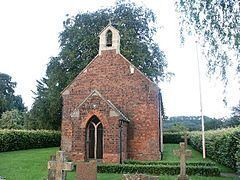
The parish church is dedicated to Saint Nicholas and is a Grade II listed building dating from 1892. Built of red brick and limestone, with a 15th-century octagonal font. There is a monument to Sir John Guevara, died 1607, of white, grey and orange streaked alabaster and a black marble inscription plaque to Francis Velles de Guevara, died 1592.
The village is probably best known for RAF Stenigot, a chain home high station during the Second World War and later as a NATO ACE High station, with four tropospheric scatter parabolic dishes.