
Demonym(s) Steindenaar, Steinder Website www.gemeentestein.nl Local time Monday 8:54 AM Area code 046 | Elevation 61 m (200 ft) Time zone CET (UTC+1) Area 22.78 km² | |
 | ||
Postcode 6129, 6170–6171, 6180–6181 Weather 5°C, Wind E at 8 km/h, 81% Humidity | ||
Stein ( pronunciation ) is a municipality and a town in the southeastern Netherlands. The municipality had a population of 25,224 in 2014 and covers an area of 22.62 km2 (8.73 sq mi) of which 1.47 km2 (0.57 sq mi) is water.
Contents
Map of Stein, Netherlands
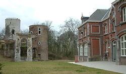
The municipality of Stein makes part of the region of South Limburg and lies between the city of Geleen in the east and Beek in the southeast, and lies furthermore west of interchange Kerensheide and the chemical industries of Chemelot. To the west lies the Belgian border, across the Meuse river. In comparison to other cities and villages in the area, Stein is fairly big. It is also the capital city of the municipality with the same name. It has i.a. three Roman Catholic churches, an abandoned mediaeval castle, and a port to the Juliana Canal which used to be the second largest inland port in all of Europe.
On 29 October 2009, the shopping mall of Stein suffered a severe fire. As a result of the calamity, the town subsequently lost 40 shops, 2 banks, 1 restaurant and 6 houses. The adjacent, iconic, 11-story apartment building 'De Stevel', remained intact.
Population centres
(Local language in parentheses.)
Dutch topographic map of the municipality of Stein, June 2015