
Demonym(s) Stazzemesi Postal code 55040 | Elevation 453 m (1,486 ft) Area 80.72 km² Local time Monday 2:21 AM | |
 | ||
Frazioni Arni, Cardoso, Farnocchia, Gallena, La Culla, Levigliani, Mulina, Palagnana, Pomezzana, Pontestazzemese, Pruno, Retignano, Ruosina, Sant'Anna, Stazzema, Terrinca, Volegno Weather 8°C, Wind NE at 19 km/h, 77% Humidity | ||
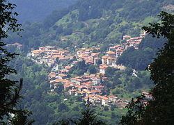
Stazzema is a comune (municipality) in the Province of Lucca in the Italian region Tuscany, located about 80 kilometres (50 miles) northwest of Florence and about 25 km (16 mi) northwest of Lucca.
Contents
Map of 55040 Stazzema Province of Lucca, Italy
History
During World War II, the village of Sant'Anna di Stazzema was the site of a massacre of civil population by German SS soldiers (12 August 1944). A total of 560 people were killed, among them 100 children, one of them only 20 days old. The city received the Gold Medal for Military Valour after the war.
Geography
Stazzema borders the following municipalities: Camaiore, Careggine, Massa, Molazzana, Pescaglia, Pietrasanta, Seravezza, Vagli Sotto, Vergemoli.
Hamlets
Stazzema is composed of 17 hamlets (frazioni):
Arni, Cardoso, Farnocchia, Gallena, La Culla, Levigliani, Mulina, Palagnana, Pomezzana, Pontestazzemese, Pruno, Retignano, Ruosina, Sant'Anna, Stazzema, Terrinca, and Volegno. Despite municipal name, the town hall is not located in Stazzema, but in the nearby hamlet of Pontestazzemese.