
Municipal assoc. Stavenhagen Time zone CET/CEST (UTC+1/+2) Population 5,978 (31 Dec 2008) Postal code 17153 | Elevation 45 m (148 ft) Area 40.84 km² Local time Monday 12:53 AM Dialling code 039954 | |
 | ||
Weather 3°C, Wind SW at 3 km/h, 91% Humidity | ||
Stavenhagen ( [ʃtaːvənˈhaːɡən]) is a municipality in the Mecklenburgische Seenplatte district, in Mecklenburg-Vorpommern, Germany. It is situated 28 km northwest of Neubrandenburg.
Contents
- Map of 17153 Stavenhagen Germany
- Subdivisions
- History
- Attractions
- Famous people from Stavenhagen
- Entreprises
- Town twinning
- References
Map of 17153 Stavenhagen, Germany
Subdivisions
Stavenhagen is divided into following parts:
History
The town is first mentioned in 1230 under the name of Stovenhage.
The town was destroyed towards the end of the Thirty Years' War in 1648. Large fires in the years 1727 and 1746 also destroyed large parts of the town.
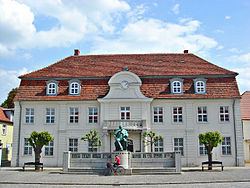
Today's Schloss Stavenhagen (Stavenhagen Castle) was built in 1740 on the premises of an earlier fort. The town's church was re-built between 1774 and 1790 and also a new town hall was erected in 1788. The first lager beer brewery in Mecklenburg was founded in Stavenhagen in the first half of the 19th century.
Fritz Reuter, a notable author (his works were among the best selling of his time), was born in 1810 as son of the mayor. Reuter is regarded one of the most prominent authors of Low German literature.
In 1864, Stavenhagen gained access to the railway network. The station is on the Buetzow-Szczecin line.
Industrial developments at the turn of the 19th century were a sugar factory, a steam mill, a brick factory, a power station, a hospital and a fire station.
Since 1960, the town features a museum dedicated to Fritz Reuter called Fritz-Reuter-Literaturmuseum.
The GDR's National People's Army opened a military base at Basepohl in 1974.